Thevenard geodata
Thevenard (South Australia) is a populated place; located in Australia in Australia/Adelaide (GMT+10.5) time zone. With population of 532 people, there are 4773 cities with bigger population in this country. Compared to other cities in Australia, 63.1% of cities are located further ↓South; 86.8% of cities are located further →East and 77.5% of cities have higher elevation than Thevenard. Note1


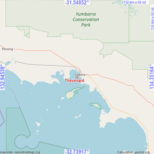
Thevenard GPS coordinates[2]
32° 8' 44.844" South, 133° 38' 54.636" East
| Map corner | latitude | longitude |
|---|---|---|
| Upper-left | -31.54852°, | 132.94539° |
| Center: | -32.14579°, | 133.64851° |
| Lower-right: | -32.73917°, | 134.35164° |
| Map W x H: | 132.4×132.4 km | = 82.3×82.3mi |
| max Lat: | -10.58257° ⇑36.9% North |
| Thevenard: | -32.14579° |
| min Lat: | ⇓63.1% South -43.31423° |
| min Long | Thevenard | max Long |
| 113.53327° | 133.64851° | 153.61246° |
| W 13.2%⇐ | ⇒86.8% E |
Elevation
Elevation of Thevenard is 17 m = 56 ft, and this is 105 m = 344 ft below average elevation for this country.
| Max E: |
1715 m = 5627 ft | 77.5% |
| Avg. | 122 m = 400 ft | |
| Thevenard | 17 m = 56 ft | |
Min E: |
-2 m = -7 ft | 22.5% |
See also: Australia elevation on elevation.city.
Geographical zone
Thevenard is located in South temperate zone (between Tropic of Capricorn and the Antarctic Circle). Distance of this Southern Tropic circle is 968.4 km =601.7 mi to North.| Distance of | km | miles | from Thevenard |
|---|---|---|---|
| Equator | 3574.3 | 2221 | to North |
| Tropic Capricorn | 968.4 | 601.7 | to North |
| Antarctic Circle | 3826.9 | 2377.9 | to South |
| South Pole | 6432.8 | 3997.2 | to South |


Nearby cities:
15 places around Thevenard: (largest is in red/bold)
• Arno Bay
334.7 km =208 mi,  125°
125°
• Ceduna
3.1 km =1.9 mi,  46°
46°
• Cleve
317.3 km =197.2 mi,  122°
122°
• Coffin Bay
312.1 km =193.9 mi,  150°
150°
• Coober Pedy
363.9 km =226.1 mi,  16°
16°
• Cowell
350 km =217.5 mi, 119°
• Cummins
304.7 km =189.3 mi,  140°
140°
• Kimba
282 km =175.2 mi,  113°
113°
• Port Lincoln
353.5 km =219.7 mi, 144°
• Roxby Downs
355 km =220.6 mi,  60°
60°
• Smoky Bay
37.3 km =23.2 mi, 133°
• Streaky Bay
89.4 km =55.6 mi, 143°
• Tumby Bay
336.9 km =209.3 mi, 137°
• Whyalla Jenkins
374.9 km =233 mi, 105°
• Wudinna
197.5 km =122.7 mi, 120°
Sources, notices
• [Note1] Compared only with cities in Australia existing in our database
• [Src1] Map data: © OpenStreetMap contributors (CC-BY-SA)
• [Src2] Other city data from geonames.org with taken over terms of usage.
• [Src3] Geographical zone / Annual Mean Temperature by Robert A. Rohde @ Wikipedia
