Ceduna geodata
Ceduna (South Australia) is a populated place; located in Australia in Australia/Adelaide (GMT+10.5) time zone. With population of 2,091 people, there are 2833 cities with bigger population in this country. Compared to other cities in Australia, 63.3% of cities are located further ↓South; 86.8% of cities are located further →East and 95.5% of cities have higher elevation than Ceduna. Note1


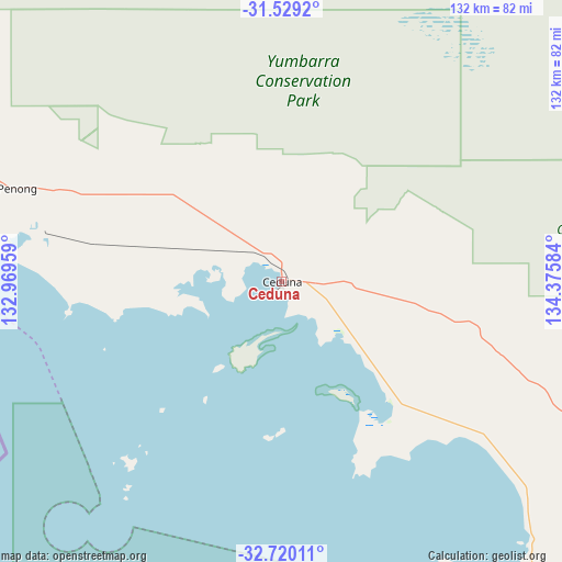
Ceduna GPS coordinates[2]
32° 7' 35.76" South, 133° 40' 21.756" East
| Map corner | latitude | longitude |
|---|---|---|
| Upper-left | -31.5292°, | 132.96959° |
| Center: | -32.1266°, | 133.67271° |
| Lower-right: | -32.72011°, | 134.37584° |
| Map W x H: | 132.4×132.4 km | = 82.3×82.3mi |
| max Lat: | -10.58257° ⇑36.7% North |
| Ceduna: | -32.1266° |
| min Lat: | ⇓63.3% South -43.31423° |
| min Long | Ceduna | max Long |
| 113.53327° | 133.67271° | 153.61246° |
| W 13.2%⇐ | ⇒86.8% E |
Elevation
Elevation of Ceduna is 6 m = 20 ft, and this is 116 m = 381 ft below average elevation for this country.
| Max E: |
1715 m = 5627 ft | 95.5% |
| Avg. | 122 m = 400 ft | |
| Ceduna | 6 m = 20 ft | |
Min E: |
-2 m = -7 ft | 4.5% |
See also: Australia elevation on elevation.city.
Geographical zone
Ceduna is located in South temperate zone (between Tropic of Capricorn and the Antarctic Circle). Distance of this Southern Tropic circle is 966.2 km =600.4 mi to North.| Distance of | km | miles | from Ceduna |
|---|---|---|---|
| Equator | 3572.1 | 2219.6 | to North |
| Tropic Capricorn | 966.2 | 600.4 | to North |
| Antarctic Circle | 3829 | 2379.2 | to South |
| South Pole | 6434.9 | 3998.5 | to South |


Nearby cities:
15 places around Ceduna: (largest is in red/bold)
• Arno Bay
334.2 km =207.7 mi,  126°
126°
• Cleve
316.6 km =196.7 mi,  123°
123°
• Coffin Bay
312.8 km =194.4 mi,  150°
150°
• Coober Pedy
361.2 km =224.4 mi,  16°
16°
• Cowell
349.1 km =216.9 mi, 119°
• Cummins
304.9 km =189.5 mi,  141°
141°
• Kimba
280.8 km =174.5 mi,  113°
113°
• Port Lincoln
353.9 km =219.9 mi, 144°
• Roxby Downs
351.9 km =218.7 mi,  60°
60°
• Smoky Bay
37.3 km =23.2 mi, 138°
• Streaky Bay
89.8 km =55.8 mi, 145°
• Thevenard
3.1 km =1.9 mi,  226°
226°
• Tumby Bay
337 km =209.4 mi, 137°
• Whyalla Jenkins
373.3 km =232 mi, 105°
• Wudinna
196.7 km =122.2 mi, 121°
Sources, notices
• [Note1] Compared only with cities in Australia existing in our database
• [Src1] Map data: © OpenStreetMap contributors (CC-BY-SA)
• [Src2] Other city data from geonames.org with taken over terms of usage.
• [Src3] Geographical zone / Annual Mean Temperature by Robert A. Rohde @ Wikipedia
