Dimboola geodata
Dimboola (Victoria) is a populated place; located in Australia in Australia/Melbourne (GMT+11) time zone. With population of 1,672 people, there are 3120 cities with bigger population in this country. Compared to other cities in Australia, 80% of cities are located further ↑North; 74.9% of cities are located further →East and 71.7% of cities have lower elevation than Dimboola. Note1


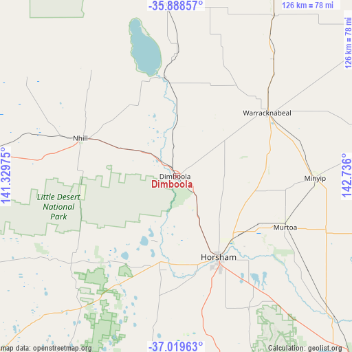
Dimboola GPS coordinates[2]
36° 27' 22.176" South, 142° 1' 58.332" East
| Map corner | latitude | longitude |
|---|---|---|
| Upper-left | -35.88857°, | 141.32975° |
| Center: | -36.45616°, | 142.03287° |
| Lower-right: | -37.01963°, | 142.736° |
| Map W x H: | 125.8×125.8 km | = 78.2×78.2mi |
| max Lat: | -10.58257° ⇑80% North |
| Dimboola: | -36.45616° |
| min Lat: | ⇓20% South -43.31423° |
| min Long | Dimboola | max Long |
| 113.53327° | 142.03287° | 153.61246° |
| W 25.1%⇐ | ⇒74.9% E |
Elevation
Elevation of Dimboola is 111 m = 364 ft, and this is 11 m = 36 ft below average elevation for this country.
| Max E: |
1715 m = 5627 ft | 28.3% |
| Avg. | 122 m = 400 ft | |
| Dimboola | 111 m = 364 ft | |
Min E: |
-2 m = -7 ft | 71.7% |
See also: Australia elevation on elevation.city.
Geographical zone
Dimboola is located in South temperate zone (between Tropic of Capricorn and the Antarctic Circle). Distance of this Southern Tropic circle is 1447.6 km =899.5 mi to North.| Distance of | km | miles | from Dimboola |
|---|---|---|---|
| Equator | 4053.5 | 2518.7 | to North |
| Tropic Capricorn | 1447.6 | 899.5 | to North |
| Antarctic Circle | 3347.6 | 2080.1 | to South |
| South Pole | 5953.5 | 3699.3 | to South |


Nearby cities:
15 places around Dimboola: (largest is in red/bold)
• Birchip
95.1 km =59.1 mi,  56°
56°
• Bordertown
114.1 km =70.9 mi,  278°
278°
• Donald
85.4 km =53.1 mi,  83°
83°
• Edenhope
92 km =57.2 mi,  225°
225°
• Halls Gap
88.3 km =54.9 mi,  150°
150°
• Haven
36.8 km =22.9 mi,  156°
156°
• Hopetoun
86.4 km =53.7 mi,  20°
20°
• Horsham
32 km =19.9 mi, 152°
• Kaniva
71.3 km =44.3 mi, 276°
• Murtoa
42.8 km =26.6 mi,  115°
115°
• Nhill
36.9 km =22.9 mi,  291°
291°
• Rainbow
62.4 km =38.8 mi,  357°
357°
• Rupanyup
56.8 km =35.3 mi,  109°
109°
• Stawell
94.3 km =58.6 mi,  135°
135°
• Warracknabeal
39.3 km =24.4 mi, 55°
Sources, notices
• [Note1] Compared only with cities in Australia existing in our database
• [Src1] Map data: © OpenStreetMap contributors (CC-BY-SA)
• [Src2] Other city data from geonames.org with taken over terms of usage.
• [Src3] Geographical zone / Annual Mean Temperature by Robert A. Rohde @ Wikipedia
