Tara geodata
Tara (Queensland) is a populated place; located in Australia in Australia/Brisbane (GMT+10) time zone. With population of 2,272 people, there are 2713 cities with bigger population in this country. Compared to other cities in Australia, 84.7% of cities are located further ↓South; 58.4% of cities are located further ←West and 88% of cities have lower elevation than Tara. Note1


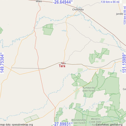
Tara GPS coordinates[2]
27° 16' 34.068" South, 150° 27' 24.336" East
| Map corner | latitude | longitude |
|---|---|---|
| Upper-left | -26.64944°, | 149.75364° |
| Center: | -27.27613°, | 150.45676° |
| Lower-right: | -27.89931°, | 151.15989° |
| Map W x H: | 139×139 km | = 86.4×86.4mi |
| max Lat: | -10.58257° ⇑15.3% North |
| Tara: | -27.27613° |
| min Lat: | ⇓84.7% South -43.31423° |
| min Long | Tara | max Long |
| 113.53327° | 150.45676° | 153.61246° |
| W 58.4%⇐ | ⇒41.6% E |
Elevation
Elevation of Tara is 313 m = 1027 ft, and this is 191 m = 627 ft above average elevation for this country.
| Max E: |
1715 m = 5627 ft | 12% |
| Tara | 313 m 1027 ft | |
| Avg. | 122 m = 400 ft | |
Min E: |
-2 m = -7 ft | 88% |
See also: Australia elevation on elevation.city.
Geographical zone
Tara is located in South temperate zone (between Tropic of Capricorn and the Antarctic Circle). Distance of this Southern Tropic circle is 426.9 km =265.3 mi to North.| Distance of | km | miles | from Tara |
|---|---|---|---|
| Equator | 3032.8 | 1884.5 | to North |
| Tropic Capricorn | 426.9 | 265.3 | to North |
| Antarctic Circle | 4368.4 | 2714.4 | to South |
| South Pole | 6974.2 | 4333.6 | to South |


Nearby cities:
15 places around Tara: (largest is in red/bold)
• Chinchilla
62.3 km =38.7 mi,  15°
15°
• Dalby
80.3 km =49.9 mi,  82°
82°
• Goombungee
137.8 km =85.6 mi,  91°
91°
• Goondiwindi
142.1 km =88.3 mi,  186°
186°
• Inglewood
140.8 km =87.5 mi,  154°
154°
• Jandowae
84.9 km =52.8 mi,  49°
49°
• Kingsthorpe
135.8 km =84.4 mi,  99°
99°
• Meringandan West
142.1 km =88.3 mi, 96°
• Miles
73.7 km =45.8 mi,  338°
338°
• Millmerran
104.5 km =64.9 mi,  129°
129°
• Oakey
126 km =78.3 mi, 97°
• Pittsworth
126 km =78.3 mi,  112°
112°
• Southbrook
132.3 km =82.2 mi, 110°
• Wandoan
137.4 km =85.4 mi, 338°
• Westcourt
61 km =37.9 mi,  330°
330°
Sources, notices
• [Note1] Compared only with cities in Australia existing in our database
• [Src1] Map data: © OpenStreetMap contributors (CC-BY-SA)
• [Src2] Other city data from geonames.org with taken over terms of usage.
• [Src3] Geographical zone / Annual Mean Temperature by Robert A. Rohde @ Wikipedia
