Qusar geodata
Qusar is a seat of a first-order administrative division; located in Azerbaijan in Asia/Baku (GMT+4) time zone. With population of 16,022 people, there are 51 cities with bigger population in this country. Compared to other cities in Azerbaijan, 93% of cities are located further ↓South; 60% of cities are located further ←West and 74.6% of cities have lower elevation than Qusar. Note1


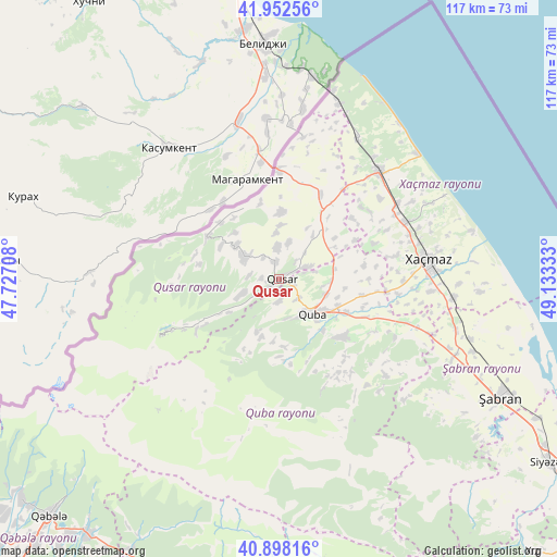
Qusar GPS coordinates[2]
41° 25' 39" North, 48° 25' 48.72" East
| Map corner | latitude | longitude |
|---|---|---|
| Upper-left | 41.95256°, | 47.72708° |
| Center: | 41.4275°, | 48.4302° |
| Lower-right: | 40.89816°, | 49.13333° |
| Map W x H: | 117.2×117.2 km | = 72.8×72.8mi |
| max Lat: | 41.75259° ⇑7% North |
| Qusar: | 41.4275° |
| min Lat: | ⇓93% South 38.45598° |
| min Long | Qusar | max Long |
| 44.84846° | 48.4302° | 50.84003° |
| W 60%⇐ | ⇒40% E |
Elevation
Elevation of Qusar is 681 m = 2234 ft, and this is 298 m = 978 ft above average elevation for this country.
| Max E: |
2211 m = 7254 ft | 25.4% |
| Qusar | 681 m 2234 ft | |
| Avg. | 383 m = 1257 ft | |
Min E: |
-26 m = -85 ft | 74.6% |
See also: Azerbaijan elevation on elevation.city.
Geographical zone
Qusar is located in North temperate zone (between Tropic of Cancer and the Arctic Circle). Distance of this Northern Tropic circle is 2000.4 km =1243 mi to South.| Distance of | km | miles | from Qusar |
|---|---|---|---|
| North Pole | 5400.8 | 3355.9 | to North |
| Arctic Circle | 2794.9 | 1736.7 | to North |
| Tropic Cancer | 2000.4 | 1243 | to South |
| Equator | 4606.3 | 2862.2 | to South |


Nearby cities:
15 places around Qusar: (largest is in red/bold)
• Altıağac
76.2 km =47.3 mi,  146°
146°
• Basqal
74.8 km =46.5 mi,  182°
182°
• Divichibazar
52.9 km =32.9 mi,  118°
118°
• Gilgilçay
63.8 km =39.6 mi, 120°
• Hacıhüseynli
18.5 km =11.5 mi,  80°
80°
• Khyzy
79 km =49.1 mi,  136°
136°
• Kyzyl-Burun
69.2 km =43 mi, 124°
• Lahıc
64.8 km =40.3 mi, 183°
• Oğuz
89.9 km =55.9 mi,  243°
243°
• Quba
10.1 km =6.3 mi, 136°
• Qutqashen
69.4 km =43.1 mi,  224°
224°
• Samur
23.3 km =14.5 mi,  0°
0°
• Xaçmaz
31.6 km =19.6 mi, 82°
• Xudat
30.8 km =19.1 mi,  42°
42°
• İsmayıllı
75.2 km =46.7 mi,  198°
198°
Sources, notices
• [Note1] Compared only with cities in Azerbaijan existing in our database
• [Src1] Map data: © OpenStreetMap contributors (CC-BY-SA)
• [Src2] Other city data from geonames.org with taken over terms of usage.
• [Src3] Geographical zone / Annual Mean Temperature by Robert A. Rohde @ Wikipedia
