Quba geodata
Quba is a seat of a first-order administrative division; located in Azerbaijan in Asia/Baku (GMT+4) time zone. With population of 22,405 people, there are 36 cities with bigger population in this country. Compared to other cities in Azerbaijan, 91.4% of cities are located further ↓South; 62.2% of cities are located further ←West and 71.4% of cities have lower elevation than Quba. Note1


Quba GPS coordinates[2]
41° 21' 39.888" North, 48° 30' 48.276" East
| Map corner | latitude | longitude |
|---|---|---|
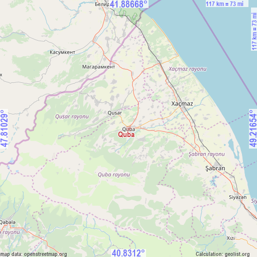
| Upper-left | 41.88668°, | 47.81029° |
| Center: | 41.36108°, | 48.51341° |
| Lower-right: | 40.8312°, | 49.21654° |
| Map W x H: | 117.4×117.4 km | = 72.9×72.9mi |
| max Lat: | 41.75259° ⇑8.6% North |
| Quba: | 41.36108° |
| min Lat: | ⇓91.4% South 38.45598° |
| min Long | Quba | max Long |
| 44.84846° | 48.51341° | 50.84003° |
| W 62.2%⇐ | ⇒37.8% E |
Elevation
Elevation of Quba is 600 m = 1969 ft, and this is 217 m = 712 ft above average elevation for this country.
| Max E: |
2211 m = 7254 ft | 28.6% |
| Quba | 600 m 1969 ft | |
| Avg. | 383 m = 1257 ft | |
Min E: |
-26 m = -85 ft | 71.4% |
See also: Azerbaijan elevation on elevation.city.
Geographical zone
Quba is located in North temperate zone (between Tropic of Cancer and the Arctic Circle). Distance of this Northern Tropic circle is 1993 km =1238.4 mi to South.| Distance of | km | miles | from Quba |
|---|---|---|---|
| North Pole | 5408.1 | 3360.4 | to North |
| Arctic Circle | 2802.3 | 1741.3 | to North |
| Tropic Cancer | 1993 | 1238.4 | to South |
| Equator | 4598.9 | 2857.6 | to South |


Nearby cities:
15 places around Quba: (largest is in red/bold)
• Altıağac
66.2 km =41.1 mi,  147°
147°
• Basqal
68.1 km =42.3 mi,  188°
188°
• Divichibazar
43.4 km =27 mi,  114°
114°
• Gilgilçay
54.2 km =33.7 mi,  117°
117°
• Hacıhüseynli
15.5 km =9.6 mi,  46°
46°
• Khyzy
68.9 km =42.8 mi,  136°
136°
• Kyzyl-Burun
59.4 km =36.9 mi, 121°
• Lahıc
58.3 km =36.2 mi, 190°
• Qusar
10.1 km =6.3 mi,  316°
316°
• Qutqashen
69.7 km =43.3 mi,  232°
232°
• Samur
31.4 km =19.5 mi,  347°
347°
• Shamakhi
81.8 km =50.8 mi,  172°
172°
• Xaçmaz
26.9 km =16.7 mi,  64°
64°
• Xudat
33.1 km =20.6 mi,  25°
25°
• İsmayıllı
70.9 km =44.1 mi,  205°
205°
Sources, notices
• [Note1] Compared only with cities in Azerbaijan existing in our database
• [Src1] Map data: © OpenStreetMap contributors (CC-BY-SA)
• [Src2] Other city data from geonames.org with taken over terms of usage.
• [Src3] Geographical zone / Annual Mean Temperature by Robert A. Rohde @ Wikipedia
