Nouna geodata
Nouna (Boucle du Mouhoun) is a seat of a second-order administrative division; located in Burkina Faso in Africa/Ouagadougou (GMT+0) time zone. With population of 29,048 people, there are 15 cities with bigger population in this country. Compared to other cities in Burkina Faso, 67.1% of cities are located further ↓South; 93.7% of cities are located further →East and 83.5% of cities have higher elevation than Nouna. Note1


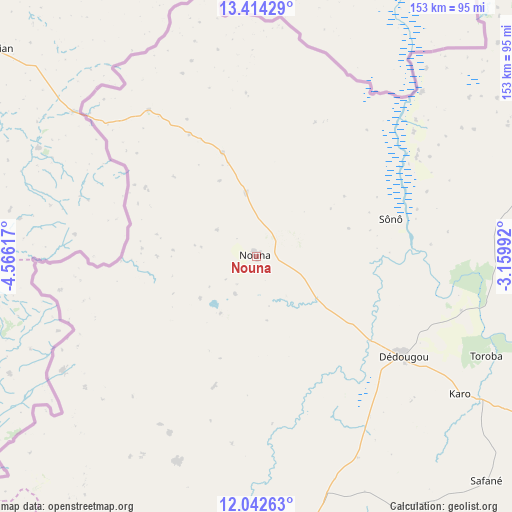
Nouna GPS coordinates[2]
12° 43' 45.804" North, 3° 51' 46.98" West
| Map corner | latitude | longitude |
|---|---|---|
| Upper-left | 13.41429°, | -4.56617° |
| Center: | 12.72939°, | -3.86305° |
| Lower-right: | 12.04263°, | -3.15992° |
| Map W x H: | 152.5×152.5 km | = 94.8×94.8mi |
| max Lat: | 14.96549° ⇑32.9% North |
| Nouna: | 12.72939° |
| min Lat: | ⇓67.1% South 9.88333° |
| min Long | Nouna | max Long |
| -5.16667° | -3.86305° | 1.78838° |
| W 6.3%⇐ | ⇒93.7% E |
Elevation
Elevation of Nouna is 277 m = 909 ft, and this is 26 m = 85 ft below average elevation for this country.
| Max E: |
423 m = 1388 ft | 83.5% |
| Avg. | 303 m = 994 ft | |
| Nouna | 277 m = 909 ft | |
Min E: |
222 m = 728 ft | 16.5% |
See also: Burkina Faso elevation on elevation.city.
Geographical zone
Nouna is located in North Torrid zone (between Equator and Tropic of Cancer). Distance of this Northern Tropic circle is 1190.5 km =739.7 mi to North.| Distance of | km | miles | from Nouna |
|---|---|---|---|
| North Pole | 8591.7 | 5338.6 | to North |
| Arctic Circle | 5985.8 | 3719.4 | to North |
| Tropic Cancer | 1190.5 | 739.7 | to North |
| Equator | 1415.4 | 879.5 | to South |


Nearby cities:
15 places around Nouna: (largest is in red/bold)
• Barani
49 km =30.4 mi,  356°
356°
• Bobo-Dioulasso
179 km =111.2 mi,  195°
195°
• Boromo
149.2 km =92.7 mi,  137°
137°
• Dédougou
52.7 km =32.7 mi,  124°
124°
• Gourcy
171.4 km =106.5 mi,  71°
71°
• Gousi
116.1 km =72.1 mi,  94°
94°
• Houndé
141.8 km =88.1 mi,  164°
164°
• Koudougou
171.3 km =106.4 mi,  108°
108°
• Ouahigouya
182.6 km =113.5 mi,  58°
58°
• Réo
157.8 km =98.1 mi, 106°
• Salanso
66.3 km =41.2 mi, 201°
• Sièn
104.7 km =65.1 mi, 92°
• Toma
104.6 km =65 mi, 88°
• Tougan
94.1 km =58.5 mi, 66°
• Yako
175.6 km =109.1 mi,  81°
81°
Sources, notices
• [Note1] Compared only with cities in Burkina Faso existing in our database
• [Src1] Map data: © OpenStreetMap contributors (CC-BY-SA)
• [Src2] Other city data from geonames.org with taken over terms of usage.
• [Src3] Geographical zone / Annual Mean Temperature by Robert A. Rohde @ Wikipedia
