Barani geodata
Barani (Boucle du Mouhoun) is a seat of a third-order administrative division; located in Burkina Faso in Africa/Ouagadougou (GMT+0) time zone. With population of 5,000 people, there are 43 cities with bigger population in this country. Compared to other cities in Burkina Faso, 83.5% of cities are located further ↓South; 94.9% of cities are located further →East and 77.2% of cities have higher elevation than Barani. Note1


Barani GPS coordinates[2]
13° 10' 8.76" North, 3° 53' 23.64" West
| Map corner | latitude | longitude |
|---|---|---|
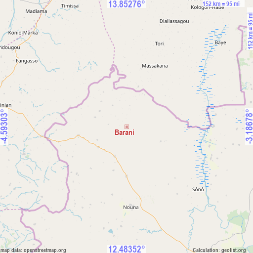
| Upper-left | 13.85276°, | -4.59303° |
| Center: | 13.1691°, | -3.8899° |
| Lower-right: | 12.48352°, | -3.18678° |
| Map W x H: | 152.2×152.2 km | = 94.6×94.6mi |
| max Lat: | 14.96549° ⇑16.5% North |
| Barani: | 13.1691° |
| min Lat: | ⇓83.5% South 9.88333° |
| min Long | Barani | max Long |
| -5.16667° | -3.8899° | 1.78838° |
| W 5.1%⇐ | ⇒94.9% E |
Elevation
Elevation of Barani is 283 m = 928 ft, and this is 20 m = 66 ft below average elevation for this country.
| Max E: |
423 m = 1388 ft | 77.2% |
| Avg. | 303 m = 994 ft | |
| Barani | 283 m = 928 ft | |
Min E: |
222 m = 728 ft | 22.8% |
See also: Burkina Faso elevation on elevation.city.
Geographical zone
Barani is located in North Torrid zone (between Equator and Tropic of Cancer). Distance of this Northern Tropic circle is 1141.7 km =709.4 mi to North.| Distance of | km | miles | from Barani |
|---|---|---|---|
| North Pole | 8542.8 | 5308.2 | to North |
| Arctic Circle | 5936.9 | 3689 | to North |
| Tropic Cancer | 1141.7 | 709.4 | to North |
| Equator | 1464.3 | 909.9 | to South |


Nearby cities:
15 places around Barani: (largest is in red/bold)
• Boromo
189.5 km =117.7 mi,  146°
146°
• Dédougou
91.2 km =56.7 mi, 149°
• Gourcy
165.8 km =103 mi,  88°
88°
• Gousi
131.6 km =81.8 mi,  115°
115°
• Houndé
190 km =118.1 mi,  167°
167°
• Koudougou
194.5 km =120.9 mi, 121°
• Nouna
49 km =30.4 mi,  176°
176°
• Ouahigouya
165.4 km =102.8 mi,  73°
73°
• Réo
180.6 km =112.2 mi, 121°
• Salanso
112.6 km =70 mi,  190°
190°
• Sièn
119.8 km =74.4 mi, 116°
• Titao
208 km =129.2 mi, 71°
• Toma
116.7 km =72.5 mi,  113°
113°
• Tougan
89.5 km =55.6 mi,  96°
96°
• Yako
178 km =110.6 mi, 97°
Sources, notices
• [Note1] Compared only with cities in Burkina Faso existing in our database
• [Src1] Map data: © OpenStreetMap contributors (CC-BY-SA)
• [Src2] Other city data from geonames.org with taken over terms of usage.
• [Src3] Geographical zone / Annual Mean Temperature by Robert A. Rohde @ Wikipedia
