Pama geodata
Pama (Est) is a seat of a second-order administrative division; located in Burkina Faso in Africa/Ouagadougou (GMT+0) time zone. With population of 8,902 people, there are 38 cities with bigger population in this country. Compared to other cities in Burkina Faso, 89.9% of cities are located further ↑North; 97.5% of cities are located further ←West and 100% of cities have higher elevation than Pama. Note1


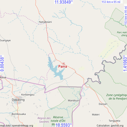
Pama GPS coordinates[2]
11° 14' 58.992" North, 0° 42' 27" East
| Map corner | latitude | longitude |
|---|---|---|
| Upper-left | 11.93849°, | 0.00438° |
| Center: | 11.24972°, | 0.7075° |
| Lower-right: | 10.5593°, | 1.41063° |
| Map W x H: | 153.4×153.4 km | = 95.3×95.3mi |
| max Lat: | 14.96549° ⇑89.9% North |
| Pama: | 11.24972° |
| min Lat: | ⇓10.1% South 9.88333° |
| min Long | Pama | max Long |
| -5.16667° | 0.7075° | 1.78838° |
| W 97.5%⇐ | ⇒2.5% E |
Elevation
Elevation of Pama is 222 m = 728 ft, and this is 81 m = 266 ft below average elevation for this country.
| Max E: |
423 m = 1388 ft | 100% |
| Avg. | 303 m = 994 ft | |
| Pama | 222 m = 728 ft | |
Min E: |
222 m = 728 ft | 0% |
See also: Burkina Faso elevation on elevation.city.
Geographical zone
Pama is located in North Torrid zone (between Equator and Tropic of Cancer). Distance of Equator is 1250.9 km =777.3 mi to South.| Distance of | km | miles | from Pama |
|---|---|---|---|
| North Pole | 8756.2 | 5440.8 | to North |
| Arctic Circle | 6150.3 | 3821.6 | to North |
| Tropic Cancer | 1355.1 | 842 | to North |
| Equator | 1250.9 | 777.3 | to South |


Nearby cities:
15 places around Pama: (largest is in red/bold)
• Bilanga
164.7 km =102.3 mi,  331°
331°
• Bogandé
212.8 km =132.2 mi, 334°
• Boulsa
210.4 km =130.7 mi,  318°
318°
• Diapaga
149.1 km =92.6 mi,  52°
52°
• Fada N'gourma
97.9 km =60.8 mi,  337°
337°
• Gaongo
220.5 km =137 mi,  292°
292°
• Garango
150.1 km =93.3 mi, 294°
• Gayéri
157.2 km =97.7 mi,  351°
351°
• Kombissiri
240.5 km =149.4 mi, 292°
• Koupéla
154.8 km =96.2 mi,  311°
311°
• Manga
199.4 km =123.9 mi,  283°
283°
• Ouargaye
76.1 km =47.3 mi, 291°
• Pô
202.2 km =125.6 mi,  267°
267°
• Tenkodogo
131.3 km =81.6 mi,  296°
296°
• Zorgo
181.9 km =113 mi, 307°
Sources, notices
• [Note1] Compared only with cities in Burkina Faso existing in our database
• [Src1] Map data: © OpenStreetMap contributors (CC-BY-SA)
• [Src2] Other city data from geonames.org with taken over terms of usage.
• [Src3] Geographical zone / Annual Mean Temperature by Robert A. Rohde @ Wikipedia
