Diapaga geodata
Diapaga (Est) is a seat of a second-order administrative division; located in Burkina Faso in Africa/Ouagadougou (GMT+0) time zone. With population of 26,013 people, there are 18 cities with bigger population in this country. Compared to other cities in Burkina Faso, 73.4% of cities are located further ↑North; 100% of cities are located further ←West and 86.1% of cities have higher elevation than Diapaga. Note1


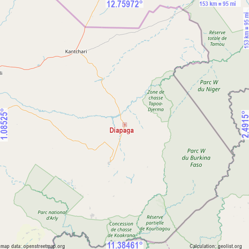
Diapaga GPS coordinates[2]
12° 4' 22.98" North, 1° 47' 18.168" East
| Map corner | latitude | longitude |
|---|---|---|
| Upper-left | 12.75972°, | 1.08525° |
| Center: | 12.07305°, | 1.78838° |
| Lower-right: | 11.38461°, | 2.4915° |
| Map W x H: | 152.9×152.9 km | = 95×95mi |
| max Lat: | 14.96549° ⇑73.4% North |
| Diapaga: | 12.07305° |
| min Lat: | ⇓26.6% South 9.88333° |
| min Long | Diapaga | max Long |
| -5.16667° | 1.78838° | 1.78838° |
| W 100%⇐ | ⇒0% E |
Elevation
Elevation of Diapaga is 273 m = 896 ft, and this is 30 m = 98 ft below average elevation for this country.
| Max E: |
423 m = 1388 ft | 86.1% |
| Avg. | 303 m = 994 ft | |
| Diapaga | 273 m = 896 ft | |
Min E: |
222 m = 728 ft | 13.9% |
See also: Burkina Faso elevation on elevation.city.
Geographical zone
Diapaga is located in North Torrid zone (between Equator and Tropic of Cancer). Distance of this Northern Tropic circle is 1263.5 km =785.1 mi to North.| Distance of | km | miles | from Diapaga |
|---|---|---|---|
| North Pole | 8664.7 | 5384 | to North |
| Arctic Circle | 6058.8 | 3764.8 | to North |
| Tropic Cancer | 1263.5 | 785.1 | to North |
| Equator | 1342.4 | 834.1 | to South |


Nearby cities:
15 places around Diapaga: (largest is in red/bold)
• Bilanga
203.8 km =126.6 mi,  284°
284°
• Bogandé
232.8 km =144.7 mi,  295°
295°
• Boulsa
265 km =164.7 mi, 284°
• Boundoré
179.6 km =111.6 mi,  327°
327°
• Dori
294.3 km =182.9 mi,  317°
317°
• Fada N'gourma
155.5 km =96.6 mi,  269°
269°
• Garango
256.2 km =159.2 mi,  263°
263°
• Gayéri
154.5 km =96 mi,  294°
294°
• Koupéla
232.9 km =144.7 mi, 272°
• Mani
254 km =157.8 mi, 301°
• Ouargaye
198.7 km =123.5 mi,  251°
251°
• Pama
149.1 km =92.6 mi,  232°
232°
• Sebba
203.9 km =126.7 mi, 318°
• Tenkodogo
237 km =147.3 mi, 262°
• Zorgo
262 km =162.8 mi, 274°
Sources, notices
• [Note1] Compared only with cities in Burkina Faso existing in our database
• [Src1] Map data: © OpenStreetMap contributors (CC-BY-SA)
• [Src2] Other city data from geonames.org with taken over terms of usage.
• [Src3] Geographical zone / Annual Mean Temperature by Robert A. Rohde @ Wikipedia
