Bogandé geodata
Bogandé (Est) is a seat of a second-order administrative division; located in Burkina Faso in Africa/Ouagadougou (GMT+0) time zone. With population of 9,854 people, there are 37 cities with bigger population in this country. Compared to other cities in Burkina Faso, 78.5% of cities are located further ↓South; 88.6% of cities are located further ←West and 73.4% of cities have higher elevation than Bogandé. Note1


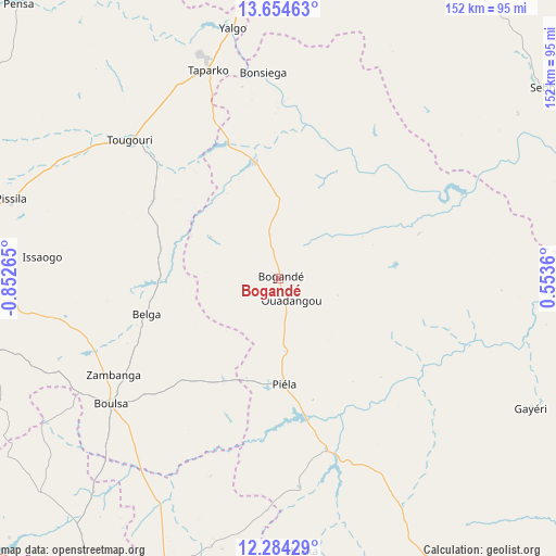
Bogandé GPS coordinates[2]
12° 58' 13.44" North, 0° 8' 58.308" West
| Map corner | latitude | longitude |
|---|---|---|
| Upper-left | 13.65463°, | -0.85265° |
| Center: | 12.9704°, | -0.14953° |
| Lower-right: | 12.28429°, | 0.5536° |
| Map W x H: | 152.4×152.4 km | = 94.7×94.7mi |
| max Lat: | 14.96549° ⇑21.5% North |
| Bogandé: | 12.9704° |
| min Lat: | ⇓78.5% South 9.88333° |
| min Long | Bogandé | max Long |
| -5.16667° | -0.14953° | 1.78838° |
| W 88.6%⇐ | ⇒11.4% E |
Elevation
Elevation of Bogandé is 287 m = 942 ft, and this is 16 m = 52 ft below average elevation for this country.
| Max E: |
423 m = 1388 ft | 73.4% |
| Avg. | 303 m = 994 ft | |
| Bogandé | 287 m = 942 ft | |
Min E: |
222 m = 728 ft | 26.6% |
See also: Burkina Faso elevation on elevation.city.
Geographical zone
Bogandé is located in North Torrid zone (between Equator and Tropic of Cancer). Distance of this Northern Tropic circle is 1163.7 km =723.1 mi to North.| Distance of | km | miles | from Bogandé |
|---|---|---|---|
| North Pole | 8564.9 | 5322 | to North |
| Arctic Circle | 5959 | 3702.7 | to North |
| Tropic Cancer | 1163.7 | 723.1 | to North |
| Equator | 1442.2 | 896.1 | to South |


Nearby cities:
15 places around Bogandé: (largest is in red/bold)
• Absouya
104.7 km =65.1 mi,  249°
249°
• Bilanga
49 km =30.4 mi,  163°
163°
• Boulsa
57.1 km =35.5 mi,  233°
233°
• Boundoré
125.8 km =78.2 mi,  65°
65°
• Boussouma
101.3 km =62.9 mi,  266°
266°
• Dori
119.1 km =74 mi,  5°
5°
• Fada N'gourma
115.1 km =71.5 mi,  151°
151°
• Gayéri
78.3 km =48.7 mi,  117°
117°
• Kaya
102.2 km =63.5 mi,  277°
277°
• Korsimoro
100.8 km =62.6 mi,  260°
260°
• Koupéla
90.7 km =56.4 mi,  193°
193°
• Mani
32.7 km =20.3 mi,  347°
347°
• Nagréongo
126.5 km =78.6 mi,  244°
244°
• Sebba
90 km =55.9 mi,  54°
54°
• Zorgo
94.8 km =58.9 mi,  212°
212°
Sources, notices
• [Note1] Compared only with cities in Burkina Faso existing in our database
• [Src1] Map data: © OpenStreetMap contributors (CC-BY-SA)
• [Src2] Other city data from geonames.org with taken over terms of usage.
• [Src3] Geographical zone / Annual Mean Temperature by Robert A. Rohde @ Wikipedia
