Sebba geodata
Sebba (Sahel) is a seat of a second-order administrative division; located in Burkina Faso in Africa/Ouagadougou (GMT+0) time zone. In our database, there are 49 cities with bigger population. Compared to other cities in Burkina Faso, 88.6% of cities are located further ↓South; 96.2% of cities are located further ←West and 96.2% of cities have higher elevation than Sebba. Note1


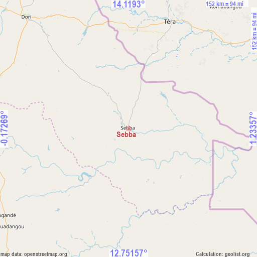
Sebba GPS coordinates[2]
13° 26' 11.076" North, 0° 31' 49.584" East
| Map corner | latitude | longitude |
|---|---|---|
| Upper-left | 14.1193°, | -0.17269° |
| Center: | 13.43641°, | 0.53044° |
| Lower-right: | 12.75157°, | 1.23357° |
| Map W x H: | 152.1×152.1 km | = 94.5×94.5mi |
| max Lat: | 14.96549° ⇑11.4% North |
| Sebba: | 13.43641° |
| min Lat: | ⇓88.6% South 9.88333° |
| min Long | Sebba | max Long |
| -5.16667° | 0.53044° | 1.78838° |
| W 96.2%⇐ | ⇒3.8% E |
Elevation
Elevation of Sebba is 252 m = 827 ft, and this is 51 m = 167 ft below average elevation for this country.
| Max E: |
423 m = 1388 ft | 96.2% |
| Avg. | 303 m = 994 ft | |
| Sebba | 252 m = 827 ft | |
Min E: |
222 m = 728 ft | 3.8% |
See also: Burkina Faso elevation on elevation.city.
Geographical zone
Sebba is located in North Torrid zone (between Equator and Tropic of Cancer). Distance of this Northern Tropic circle is 1111.9 km =690.9 mi to North.| Distance of | km | miles | from Sebba |
|---|---|---|---|
| North Pole | 8513.1 | 5289.8 | to North |
| Arctic Circle | 5907.2 | 3670.6 | to North |
| Tropic Cancer | 1111.9 | 690.9 | to North |
| Equator | 1494 | 928.3 | to South |


Nearby cities:
15 places around Sebba: (largest is in red/bold)
• Bilanga
115.8 km =72 mi,  211°
211°
• Bogandé
90 km =55.9 mi,  234°
234°
• Boulsa
147.2 km =91.5 mi, 234°
• Boundoré
40.8 km =25.4 mi,  89°
89°
• Boussouma
184.1 km =114.4 mi,  251°
251°
• Dori
90.3 km =56.1 mi,  317°
317°
• Fada N'gourma
154 km =95.7 mi,  186°
186°
• Gayéri
87.7 km =54.5 mi,  182°
182°
• Gorom-Gorom
139.1 km =86.4 mi, 323°
• Kaya
178.9 km =111.2 mi,  257°
257°
• Koupéla
169.4 km =105.3 mi, 214°
• Mani
82.8 km =51.4 mi, 256°
• Oursi
174.4 km =108.4 mi, 322°
• Tin-Akoff
185.7 km =115.4 mi,  336°
336°
• Zorgo
181.2 km =112.6 mi,  223°
223°
Sources, notices
• [Note1] Compared only with cities in Burkina Faso existing in our database
• [Src1] Map data: © OpenStreetMap contributors (CC-BY-SA)
• [Src2] Other city data from geonames.org with taken over terms of usage.
• [Src3] Geographical zone / Annual Mean Temperature by Robert A. Rohde @ Wikipedia
