Manga geodata
Manga (Bujumbura Rural) is a populated place; located in Burundi in Africa/Bujumbura (GMT+2) time zone. With population of 1,000 people, there are 17 cities with bigger population in this country. Compared to other cities in Burundi, 75% of cities are located further ↑North; 70% of cities are located further →East and 100% of cities have lower elevation than Manga. Note1


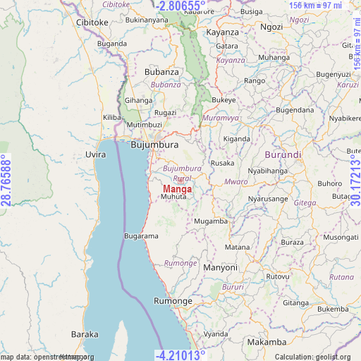
Manga GPS coordinates[2]
3° 30' 30.96" South, 29° 28' 8.4" East
| Map corner | latitude | longitude |
|---|---|---|
| Upper-left | -2.80655°, | 28.76588° |
| Center: | -3.5086°, | 29.469° |
| Lower-right: | -4.21013°, | 30.17213° |
| Map W x H: | 156.1×156.1 km | = 97×97mi |
| max Lat: | -2.5845° ⇑75% North |
| Manga: | -3.5086° |
| min Lat: | ⇓25% South -4.1348° |
| min Long | Manga | max Long |
| 29.1248° | 29.469° | 30.5528° |
| W 30%⇐ | ⇒70% E |
Elevation
Elevation of Manga is 2054 m = 6739 ft, and this is 542.6 m = 1780 ft above average elevation for this country.
| Max E: |
2054 m = 6739 ft | 0% |
| Manga | 2054 m 6739 ft | |
| Avg. | 1511.4 m = 4959 ft | |
Min E: |
790 m = 2592 ft | 100% |
See also: Burundi elevation on elevation.city.
Geographical zone
Manga is located in South Torrid zone (between Equator and Tropic of Capricorn). Distance of Equator is 390.1 km =242.4 mi to North.| Distance of | km | miles | from Manga |
|---|---|---|---|
| Equator | 390.1 | 242.4 | to North |
| Tropic Capricorn | 2215.8 | 1376.8 | to South |
| Antarctic Circle | 7011.1 | 4356.5 | to South |
| South Pole | 9616.9 | 5975.7 | to South |


Nearby cities:
15 places around Manga: (largest is in red/bold)
• Bubanza
48.4 km =30.1 mi,  349°
349°
• Buganda
67.6 km =42 mi,  333°
333°
• Bujumbura
18.5 km =11.5 mi,  319°
319°
• Bururi
51.9 km =32.2 mi,  160°
160°
• Cibitoke
79 km =49.1 mi, 331°
• Gitega
51.4 km =31.9 mi,  79°
79°
• Isale
17.8 km =11.1 mi,  5°
5°
• Kayanza
67.6 km =42 mi,  15°
15°
• Makamba
78.9 km =49 mi,  151°
151°
• Muramvya
30.9 km =19.2 mi,  29°
29°
• Muzinda
28 km =17.4 mi, 348°
• Mwaro
26 km =16.2 mi,  90°
90°
• Ngozi
78 km =48.5 mi, 30°
• Rumonge
51.8 km =32.2 mi,  183°
183°
• Rutana
74.4 km =46.2 mi,  128°
128°
Sources, notices
• [Note1] Compared only with cities in Burundi existing in our database
• [Src1] Map data: © OpenStreetMap contributors (CC-BY-SA)
• [Src2] Other city data from geonames.org with taken over terms of usage.
• [Src3] Geographical zone / Annual Mean Temperature by Robert A. Rohde @ Wikipedia
