Bubanza geodata
Bubanza is a seat of a first-order administrative division; located in Burundi in Africa/Bujumbura (GMT+2) time zone. With population of 12,728 people, there are 11 cities with bigger population in this country. Compared to other cities in Burundi, 70% of cities are located further ↓South; 85% of cities are located further →East and 75% of cities have higher elevation than Bubanza. Note1


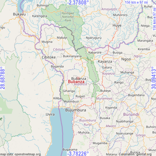
Bubanza GPS coordinates[2]
3° 4' 49.44" South, 29° 23' 27.6" East
| Map corner | latitude | longitude |
|---|---|---|
| Upper-left | -2.37808°, | 28.68788° |
| Center: | -3.0804°, | 29.391° |
| Lower-right: | -3.78226°, | 30.09413° |
| Map W x H: | 156.1×156.1 km | = 97×97mi |
| max Lat: | -2.5845° ⇑30% North |
| Bubanza: | -3.0804° |
| min Lat: | ⇓70% South -4.1348° |
| min Long | Bubanza | max Long |
| 29.1248° | 29.391° | 30.5528° |
| W 15%⇐ | ⇒85% E |
Elevation
Elevation of Bubanza is 1079 m = 3540 ft, and this is 432.4 m = 1419 ft below average elevation for this country.
| Max E: |
2054 m = 6739 ft | 75% |
| Avg. | 1511.4 m = 4959 ft | |
| Bubanza | 1079 m = 3540 ft | |
Min E: |
790 m = 2592 ft | 25% |
See also: Burundi elevation on elevation.city.
Geographical zone
Bubanza is located in South Torrid zone (between Equator and Tropic of Capricorn). Distance of Equator is 342.5 km =212.8 mi to North.| Distance of | km | miles | from Bubanza |
|---|---|---|---|
| Equator | 342.5 | 212.8 | to North |
| Tropic Capricorn | 2263.4 | 1406.4 | to South |
| Antarctic Circle | 7058.7 | 4386.1 | to South |
| South Pole | 9664.6 | 6005.3 | to South |


Nearby cities:
15 places around Bubanza: (largest is in red/bold)
• Buganda
25.2 km =15.7 mi,  300°
300°
• Bujumbura
33.7 km =20.9 mi,  185°
185°
• Bururi
100 km =62.1 mi,  164°
164°
• Cibitoke
36.6 km =22.7 mi,  306°
306°
• Gitega
70.7 km =43.9 mi,  123°
123°
• Isale
31.6 km =19.6 mi, 160°
• Karuzi
85.7 km =53.3 mi,  91°
91°
• Kayanza
31.8 km =19.8 mi,  56°
56°
• Kirundo
95.8 km =59.5 mi,  54°
54°
• Manga
48.4 km =30.1 mi,  169°
169°
• Muramvya
31.9 km =19.8 mi,  130°
130°
• Muzinda
20.4 km =12.7 mi, 170°
• Mwaro
59.1 km =36.7 mi,  144°
144°
• Ngozi
52.5 km =32.6 mi,  68°
68°
• Rumonge
99.5 km =61.8 mi,  176°
176°
Sources, notices
• [Note1] Compared only with cities in Burundi existing in our database
• [Src1] Map data: © OpenStreetMap contributors (CC-BY-SA)
• [Src2] Other city data from geonames.org with taken over terms of usage.
• [Src3] Geographical zone / Annual Mean Temperature by Robert A. Rohde @ Wikipedia
