Cibitoke geodata
Cibitoke is a seat of a first-order administrative division; located in Burundi in Africa/Bujumbura (GMT+2) time zone. With population of 14,220 people, there are 10 cities with bigger population in this country. Compared to other cities in Burundi, 90% of cities are located further ↓South; 100% of cities are located further →East and 80% of cities have higher elevation than Cibitoke. Note1


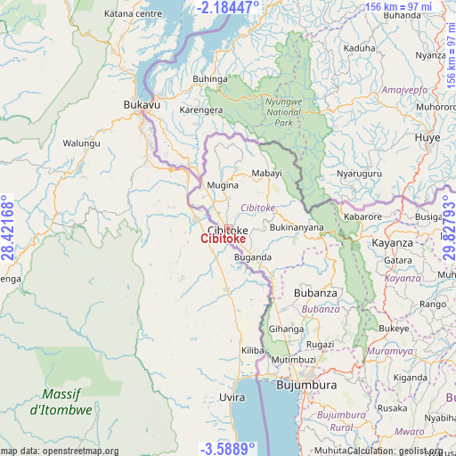
Cibitoke GPS coordinates[2]
2° 53' 12.84" South, 29° 7' 29.28" East
| Map corner | latitude | longitude |
|---|---|---|
| Upper-left | -2.18447°, | 28.42168° |
| Center: | -2.8869°, | 29.1248° |
| Lower-right: | -3.5889°, | 29.82793° |
| Map W x H: | 156.2×156.2 km | = 97.1×97.1mi |
| max Lat: | -2.5845° ⇑10% North |
| Cibitoke: | -2.8869° |
| min Lat: | ⇓90% South -4.1348° |
| min Long | Cibitoke | max Long |
| 29.1248° | 29.1248° | 30.5528° |
| W 0%⇐ | ⇒100% E |
Elevation
Elevation of Cibitoke is 937 m = 3074 ft, and this is 574.4 m = 1885 ft below average elevation for this country.
| Max E: |
2054 m = 6739 ft | 80% |
| Avg. | 1511.4 m = 4959 ft | |
| Cibitoke | 937 m = 3074 ft | |
Min E: |
790 m = 2592 ft | 20% |
See also: Burundi elevation on elevation.city.
Geographical zone
Cibitoke is located in South Torrid zone (between Equator and Tropic of Capricorn). Distance of Equator is 321 km =199.5 mi to North.| Distance of | km | miles | from Cibitoke |
|---|---|---|---|
| Equator | 321 | 199.5 | to North |
| Tropic Capricorn | 2284.9 | 1419.8 | to South |
| Antarctic Circle | 7080.2 | 4399.4 | to South |
| South Pole | 9686.1 | 6018.7 | to South |


Nearby cities:
15 places around Cibitoke: (largest is in red/bold)
• Bubanza
36.6 km =22.7 mi,  126°
126°
• Buganda
11.7 km =7.3 mi,  138°
138°
• Bujumbura
61 km =37.9 mi,  154°
154°
• Bururi
130.4 km =81 mi, 154°
• Gitega
107.2 km =66.6 mi,  124°
124°
• Isale
65 km =40.4 mi, 142°
• Karuzi
117.7 km =73.1 mi,  101°
101°
• Kayanza
56.2 km =34.9 mi,  93°
93°
• Kirundo
113 km =70.2 mi,  72°
72°
• Manga
79 km =49.1 mi, 151°
• Muramvya
68.4 km =42.5 mi, 128°
• Muzinda
53.1 km =33 mi, 141°
• Mwaro
94.6 km =58.8 mi, 137°
• Ngozi
78.4 km =48.7 mi, 91°
• Rumonge
125.7 km =78.1 mi,  163°
163°
Sources, notices
• [Note1] Compared only with cities in Burundi existing in our database
• [Src1] Map data: © OpenStreetMap contributors (CC-BY-SA)
• [Src2] Other city data from geonames.org with taken over terms of usage.
• [Src3] Geographical zone / Annual Mean Temperature by Robert A. Rohde @ Wikipedia
