Buganda geodata
Buganda (Cibitoke) is a seat of a second-order administrative division; located in Burundi in Africa/Bujumbura (GMT+2) time zone. In our database, there are 18 cities with bigger population. Compared to other cities in Burundi, 75% of cities are located further ↓South; 95% of cities are located further →East and 90% of cities have higher elevation than Buganda. Note1


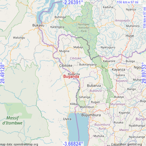
Buganda GPS coordinates[2]
2° 57' 58.68" South, 29° 11' 39.84" East
| Map corner | latitude | longitude |
|---|---|---|
| Upper-left | -2.26391°, | 28.49128° |
| Center: | -2.9663°, | 29.1944° |
| Lower-right: | -3.66824°, | 29.89753° |
| Map W x H: | 156.1×156.2 km | = 97×97.1mi |
| max Lat: | -2.5845° ⇑25% North |
| Buganda: | -2.9663° |
| min Lat: | ⇓75% South -4.1348° |
| min Long | Buganda | max Long |
| 29.1248° | 29.1944° | 30.5528° |
| W 5%⇐ | ⇒95% E |
Elevation
Elevation of Buganda is 884 m = 2900 ft, and this is 627.4 m = 2058 ft below average elevation for this country.
| Max E: |
2054 m = 6739 ft | 90% |
| Avg. | 1511.4 m = 4959 ft | |
| Buganda | 884 m = 2900 ft | |
Min E: |
790 m = 2592 ft | 10% |
See also: Burundi elevation on elevation.city.
Geographical zone
Buganda is located in South Torrid zone (between Equator and Tropic of Capricorn). Distance of Equator is 329.8 km =204.9 mi to North.| Distance of | km | miles | from Buganda |
|---|---|---|---|
| Equator | 329.8 | 204.9 | to North |
| Tropic Capricorn | 2276.1 | 1414.3 | to South |
| Antarctic Circle | 7071.4 | 4394 | to South |
| South Pole | 9677.2 | 6013.1 | to South |


Nearby cities:
15 places around Buganda: (largest is in red/bold)
• Bubanza
25.2 km =15.7 mi,  120°
120°
• Bujumbura
49.8 km =30.9 mi,  158°
158°
• Bururi
119.2 km =74.1 mi, 156°
• Cibitoke
11.7 km =7.3 mi,  318°
318°
• Gitega
95.9 km =59.6 mi, 122°
• Isale
53.3 km =33.1 mi,  142°
142°
• Karuzi
108.6 km =67.5 mi,  97°
97°
• Kayanza
48.5 km =30.1 mi,  84°
84°
• Kirundo
108.7 km =67.5 mi,  67°
67°
• Manga
67.6 km =42 mi,  153°
153°
• Muramvya
56.9 km =35.4 mi,  126°
126°
• Muzinda
41.3 km =25.7 mi, 142°
• Mwaro
82.8 km =51.4 mi, 137°
• Ngozi
70.9 km =44.1 mi, 84°
• Rumonge
115.2 km =71.6 mi,  166°
166°
Sources, notices
• [Note1] Compared only with cities in Burundi existing in our database
• [Src1] Map data: © OpenStreetMap contributors (CC-BY-SA)
• [Src2] Other city data from geonames.org with taken over terms of usage.
• [Src3] Geographical zone / Annual Mean Temperature by Robert A. Rohde @ Wikipedia
