Mwaro geodata
Mwaro is a seat of a first-order administrative division; located in Burundi in Africa/Bujumbura (GMT+2) time zone. With population of 4,924 people, there are 16 cities with bigger population in this country. Compared to other cities in Burundi, 80% of cities are located further ↑North; 55% of cities are located further ←West and 95% of cities have lower elevation than Mwaro. Note1


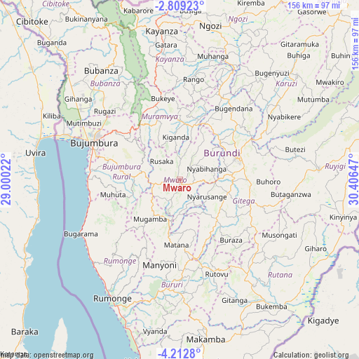
Mwaro GPS coordinates[2]
3° 30' 40.608" South, 29° 42' 12.024" East
| Map corner | latitude | longitude |
|---|---|---|
| Upper-left | -2.80923°, | 29.00022° |
| Center: | -3.51128°, | 29.70334° |
| Lower-right: | -4.2128°, | 30.40647° |
| Map W x H: | 156.1×156.1 km | = 97×97mi |
| max Lat: | -2.5845° ⇑80% North |
| Mwaro: | -3.51128° |
| min Lat: | ⇓20% South -4.1348° |
| min Long | Mwaro | max Long |
| 29.1248° | 29.70334° | 30.5528° |
| W 55%⇐ | ⇒45% E |
Elevation
Elevation of Mwaro is 1974 m = 6476 ft, and this is 462.6 m = 1518 ft above average elevation for this country.
| Max E: |
2054 m = 6739 ft | 5% |
| Mwaro | 1974 m 6476 ft | |
| Avg. | 1511.4 m = 4959 ft | |
Min E: |
790 m = 2592 ft | 95% |
See also: Burundi elevation on elevation.city.
Geographical zone
Mwaro is located in South Torrid zone (between Equator and Tropic of Capricorn). Distance of Equator is 390.4 km =242.6 mi to North.| Distance of | km | miles | from Mwaro |
|---|---|---|---|
| Equator | 390.4 | 242.6 | to North |
| Tropic Capricorn | 2215.5 | 1376.6 | to South |
| Antarctic Circle | 7010.8 | 4356.3 | to South |
| South Pole | 9616.6 | 5975.5 | to South |


Nearby cities:
15 places around Mwaro: (largest is in red/bold)
• Bubanza
59.1 km =36.7 mi,  324°
324°
• Bujumbura
40.6 km =25.2 mi,  290°
290°
• Bururi
49.4 km =30.7 mi,  190°
190°
• Gitega
26.3 km =16.3 mi,  69°
69°
• Isale
30.3 km =18.8 mi,  306°
306°
• Karuzi
68.4 km =42.5 mi,  48°
48°
• Kayanza
66 km =41 mi,  352°
352°
• Makamba
70.2 km =43.6 mi,  170°
170°
• Manga
26 km =16.2 mi,  270°
270°
• Muramvya
29 km =18 mi,  338°
338°
• Muzinda
41.9 km =26 mi, 311°
• Ngozi
68.6 km =42.6 mi,  11°
11°
• Rumonge
59.2 km =36.8 mi,  209°
209°
• Rutana
56.3 km =35 mi,  145°
145°
• Ruyigi
60.6 km =37.7 mi,  86°
86°
Sources, notices
• [Note1] Compared only with cities in Burundi existing in our database
• [Src1] Map data: © OpenStreetMap contributors (CC-BY-SA)
• [Src2] Other city data from geonames.org with taken over terms of usage.
• [Src3] Geographical zone / Annual Mean Temperature by Robert A. Rohde @ Wikipedia
