Gitega geodata
Gitega is a capital of a political entity; located in Burundi in Africa/Bujumbura (GMT+2) time zone. With population of 41,000 people, there are 2 cities with bigger population in this country. Compared to other cities in Burundi, 65% of cities are located further ↑North; 70% of cities are located further ←West and 75% of cities have lower elevation than Gitega. Note1


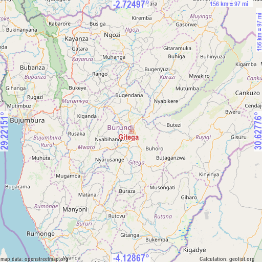
Gitega GPS coordinates[2]
3° 25' 37.488" South, 29° 55' 28.668" East
| Map corner | latitude | longitude |
|---|---|---|
| Upper-left | -2.72497°, | 29.22151° |
| Center: | -3.42708°, | 29.92463° |
| Lower-right: | -4.12867°, | 30.62776° |
| Map W x H: | 156.1×156.1 km | = 97×97mi |
| max Lat: | -2.5845° ⇑65% North |
| Gitega: | -3.42708° |
| min Lat: | ⇓35% South -4.1348° |
| min Long | Gitega | max Long |
| 29.1248° | 29.92463° | 30.5528° |
| W 70%⇐ | ⇒30% E |
Elevation
Elevation of Gitega is 1849 m = 6066 ft, and this is 337.6 m = 1108 ft above average elevation for this country.
| Max E: |
2054 m = 6739 ft | 25% |
| Gitega | 1849 m 6066 ft | |
| Avg. | 1511.4 m = 4959 ft | |
Min E: |
790 m = 2592 ft | 75% |
See also: Gitega elevation on elevation.city.
Geographical zone
Gitega is located in South Torrid zone (between Equator and Tropic of Capricorn). Distance of Equator is 381.1 km =236.8 mi to North.| Distance of | km | miles | from Gitega |
|---|---|---|---|
| Equator | 381.1 | 236.8 | to North |
| Tropic Capricorn | 2224.9 | 1382.5 | to South |
| Antarctic Circle | 7020.1 | 4362.1 | to South |
| South Pole | 9626 | 5981.3 | to South |


Nearby cities:
15 places around Gitega: (largest is in red/bold)
• Bubanza
70.7 km =43.9 mi,  303°
303°
• Bujumbura
62.7 km =39 mi,  274°
274°
• Bururi
66.9 km =41.6 mi,  209°
209°
• Cankuzo
73.5 km =45.7 mi,  71°
71°
• Isale
49.7 km =30.9 mi,  280°
280°
• Karuzi
44.8 km =27.8 mi,  36°
36°
• Kayanza
65 km =40.4 mi,  329°
329°
• Manga
51.4 km =31.9 mi,  259°
259°
• Muramvya
39.3 km =24.4 mi, 296°
• Muyinga
79.6 km =49.5 mi, 35°
• Muzinda
58.9 km =36.6 mi,  288°
288°
• Mwaro
26.3 km =16.3 mi,  249°
249°
• Ngozi
58.7 km =36.5 mi,  349°
349°
• Rutana
56.2 km =34.9 mi,  172°
172°
• Ruyigi
36.4 km =22.6 mi,  98°
98°
Sources, notices
• [Note1] Compared only with cities in Burundi existing in our database
• [Src1] Map data: © OpenStreetMap contributors (CC-BY-SA)
• [Src2] Other city data from geonames.org with taken over terms of usage.
• [Src3] Geographical zone / Annual Mean Temperature by Robert A. Rohde @ Wikipedia
