Bujumbura geodata
Bujumbura (Bujumbura Mairie) is a seat of a first-order administrative division; located in Burundi in Africa/Bujumbura (GMT+2) time zone. With population of 331,700 people, there are 0 cities with bigger population in this country. Compared to other cities in Burundi, 60% of cities are located further ↑North; 90% of cities are located further →East and 95% of cities have higher elevation than Bujumbura. Note1


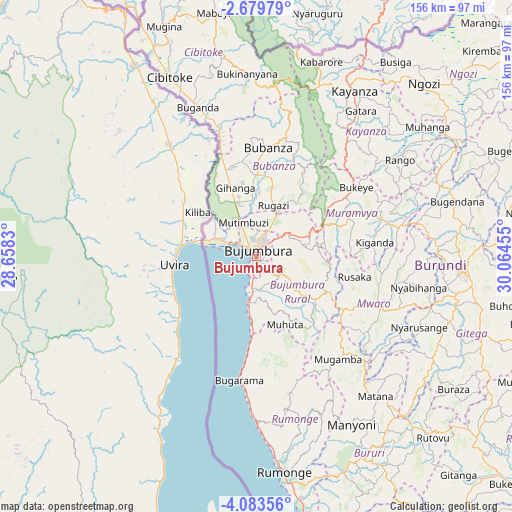
Bujumbura GPS coordinates[2]
3° 22' 54.948" South, 29° 21' 41.112" East
| Map corner | latitude | longitude |
|---|---|---|
| Upper-left | -2.67979°, | 28.6583° |
| Center: | -3.38193°, | 29.36142° |
| Lower-right: | -4.08356°, | 30.06455° |
| Map W x H: | 156.1×156.1 km | = 97×97mi |
| max Lat: | -2.5845° ⇑60% North |
| Bujumbura: | -3.38193° |
| min Lat: | ⇓40% South -4.1348° |
| min Long | Bujumbura | max Long |
| 29.1248° | 29.36142° | 30.5528° |
| W 10%⇐ | ⇒90% E |
Elevation
Elevation of Bujumbura is 795 m = 2608 ft, and this is 716.4 m = 2350 ft below average elevation for this country.
| Max E: |
2054 m = 6739 ft | 95% |
| Avg. | 1511.4 m = 4959 ft | |
| Bujumbura | 795 m = 2608 ft | |
Min E: |
790 m = 2592 ft | 5% |
See also: Bujumbura elevation on elevation.city.
Geographical zone
Bujumbura is located in South Torrid zone (between Equator and Tropic of Capricorn). Distance of Equator is 376 km =233.6 mi to North.| Distance of | km | miles | from Bujumbura |
|---|---|---|---|
| Equator | 376 | 233.6 | to North |
| Tropic Capricorn | 2229.9 | 1385.6 | to South |
| Antarctic Circle | 7025.1 | 4365.2 | to South |
| South Pole | 9631 | 5984.4 | to South |


Nearby cities:
15 places around Bujumbura: (largest is in red/bold)
• Bubanza
33.7 km =20.9 mi,  5°
5°
• Buganda
49.8 km =30.9 mi,  338°
338°
• Bururi
69.5 km =43.2 mi,  155°
155°
• Cibitoke
61 km =37.9 mi,  334°
334°
• Gitega
62.7 km =39 mi,  94°
94°
• Isale
14.1 km =8.8 mi,  74°
74°
• Karuzi
94.3 km =58.6 mi, 70°
• Kayanza
59.1 km =36.7 mi,  30°
30°
• Manga
18.5 km =11.5 mi,  139°
139°
• Muramvya
30.1 km =18.7 mi, 65°
• Muzinda
14.9 km =9.3 mi, 26°
• Mwaro
40.6 km =25.2 mi,  110°
110°
• Ngozi
74.1 km =46 mi,  44°
44°
• Rumonge
66.3 km =41.2 mi,  172°
172°
• Rutana
92.6 km =57.5 mi,  130°
130°
Sources, notices
• [Note1] Compared only with cities in Burundi existing in our database
• [Src1] Map data: © OpenStreetMap contributors (CC-BY-SA)
• [Src2] Other city data from geonames.org with taken over terms of usage.
• [Src3] Geographical zone / Annual Mean Temperature by Robert A. Rohde @ Wikipedia
