Ngozi geodata
Ngozi is a seat of a first-order administrative division; located in Burundi in Africa/Bujumbura (GMT+2) time zone. With population of 21,506 people, there are 4 cities with bigger population in this country. Compared to other cities in Burundi, 85% of cities are located further ↓South; 65% of cities are located further ←West and 70% of cities have lower elevation than Ngozi. Note1


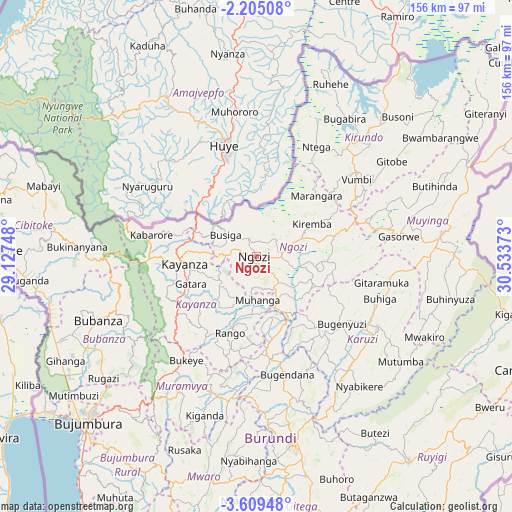
Ngozi GPS coordinates[2]
2° 54' 27" South, 29° 49' 50.16" East
| Map corner | latitude | longitude |
|---|---|---|
| Upper-left | -2.20508°, | 29.12748° |
| Center: | -2.9075°, | 29.8306° |
| Lower-right: | -3.60948°, | 30.53373° |
| Map W x H: | 156.2×156.2 km | = 97.1×97.1mi |
| max Lat: | -2.5845° ⇑15% North |
| Ngozi: | -2.9075° |
| min Lat: | ⇓85% South -4.1348° |
| min Long | Ngozi | max Long |
| 29.1248° | 29.8306° | 30.5528° |
| W 65%⇐ | ⇒35% E |
Elevation
Elevation of Ngozi is 1824 m = 5984 ft, and this is 312.6 m = 1026 ft above average elevation for this country.
| Max E: |
2054 m = 6739 ft | 30% |
| Ngozi | 1824 m 5984 ft | |
| Avg. | 1511.4 m = 4959 ft | |
Min E: |
790 m = 2592 ft | 70% |
See also: Burundi elevation on elevation.city.
Geographical zone
Ngozi is located in South Torrid zone (between Equator and Tropic of Capricorn). Distance of Equator is 323.3 km =200.9 mi to North.| Distance of | km | miles | from Ngozi |
|---|---|---|---|
| Equator | 323.3 | 200.9 | to North |
| Tropic Capricorn | 2282.6 | 1418.3 | to South |
| Antarctic Circle | 7077.9 | 4398 | to South |
| South Pole | 9683.8 | 6017.2 | to South |


Nearby cities:
15 places around Ngozi: (largest is in red/bold)
• Bubanza
52.5 km =32.6 mi,  248°
248°
• Buganda
70.9 km =44.1 mi,  264°
264°
• Bujumbura
74.1 km =46 mi,  224°
224°
• Cibitoke
78.4 km =48.7 mi,  271°
271°
• Gitega
58.7 km =36.5 mi,  169°
169°
• Isale
62.4 km =38.8 mi, 218°
• Karuzi
42.7 km =26.5 mi,  120°
120°
• Kayanza
22.4 km =13.9 mi, 265°
• Kirundo
46.5 km =28.9 mi,  39°
39°
• Manga
78 km =48.5 mi,  210°
210°
• Muramvya
47.1 km =29.3 mi, 211°
• Muyinga
57.1 km =35.5 mi,  83°
83°
• Muzinda
60.2 km =37.4 mi,  229°
229°
• Mwaro
68.6 km =42.6 mi,  191°
191°
• Ruyigi
78.5 km =48.8 mi,  143°
143°
Sources, notices
• [Note1] Compared only with cities in Burundi existing in our database
• [Src1] Map data: © OpenStreetMap contributors (CC-BY-SA)
• [Src2] Other city data from geonames.org with taken over terms of usage.
• [Src3] Geographical zone / Annual Mean Temperature by Robert A. Rohde @ Wikipedia
