Karuzi geodata
Karuzi is a seat of a first-order administrative division; located in Burundi in Africa/Bujumbura (GMT+2) time zone. With population of 10,705 people, there are 12 cities with bigger population in this country. Compared to other cities in Burundi, 65% of cities are located further ↓South; 85% of cities are located further ←West and 50% of cities have lower elevation than Karuzi. Note1


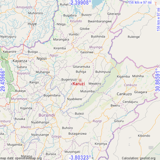
Karuzi GPS coordinates[2]
3° 6' 5.004" South, 30° 9' 46.008" East
| Map corner | latitude | longitude |
|---|---|---|
| Upper-left | -2.39908°, | 29.45966° |
| Center: | -3.10139°, | 30.16278° |
| Lower-right: | -3.80323°, | 30.86591° |
| Map W x H: | 156.1×156.1 km | = 97×97mi |
| max Lat: | -2.5845° ⇑35% North |
| Karuzi: | -3.10139° |
| min Lat: | ⇓65% South -4.1348° |
| min Long | Karuzi | max Long |
| 29.1248° | 30.16278° | 30.5528° |
| W 85%⇐ | ⇒15% E |
Elevation
Elevation of Karuzi is 1627 m = 5338 ft, and this is 115.6 m = 379 ft above average elevation for this country.
| Max E: |
2054 m = 6739 ft | 50% |
| Karuzi | 1627 m 5338 ft | |
| Avg. | 1511.4 m = 4959 ft | |
Min E: |
790 m = 2592 ft | 50% |
See also: Burundi elevation on elevation.city.
Geographical zone
Karuzi is located in South Torrid zone (between Equator and Tropic of Capricorn). Distance of Equator is 344.8 km =214.2 mi to North.| Distance of | km | miles | from Karuzi |
|---|---|---|---|
| Equator | 344.8 | 214.2 | to North |
| Tropic Capricorn | 2261.1 | 1405 | to South |
| Antarctic Circle | 7056.3 | 4384.6 | to South |
| South Pole | 9662.2 | 6003.8 | to South |


Nearby cities:
15 places around Karuzi: (largest is in red/bold)
• Bubanza
85.7 km =53.3 mi,  271°
271°
• Bujumbura
94.3 km =58.6 mi,  250°
250°
• Cankuzo
45.2 km =28.1 mi,  106°
106°
• Gitega
44.8 km =27.8 mi,  216°
216°
• Isale
80.2 km =49.8 mi, 249°
• Kayanza
62.5 km =38.8 mi,  288°
288°
• Kirundo
58 km =36 mi,  352°
352°
• Manga
89.3 km =55.5 mi,  239°
239°
• Muramvya
64.3 km =40 mi, 253°
• Muyinga
34.7 km =21.6 mi,  34°
34°
• Muzinda
84.3 km =52.4 mi,  257°
257°
• Mwaro
68.4 km =42.5 mi,  228°
228°
• Ngozi
42.7 km =26.5 mi,  300°
300°
• Rutana
93.8 km =58.3 mi,  191°
191°
• Ruyigi
42.8 km =26.6 mi,  167°
167°
Sources, notices
• [Note1] Compared only with cities in Burundi existing in our database
• [Src1] Map data: © OpenStreetMap contributors (CC-BY-SA)
• [Src2] Other city data from geonames.org with taken over terms of usage.
• [Src3] Geographical zone / Annual Mean Temperature by Robert A. Rohde @ Wikipedia
