Ruyigi geodata
Ruyigi is a seat of a first-order administrative division; located in Burundi in Africa/Bujumbura (GMT+2) time zone. With population of 38,458 people, there are 3 cities with bigger population in this country. Compared to other cities in Burundi, 70% of cities are located further ↑North; 90% of cities are located further ←West and 60% of cities have higher elevation than Ruyigi. Note1


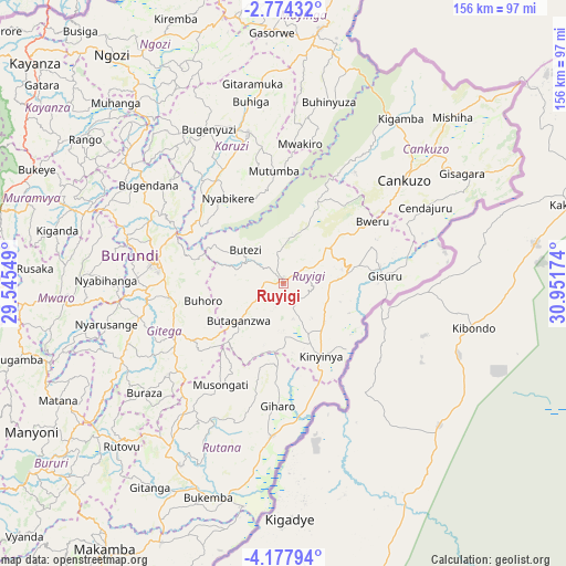
Ruyigi GPS coordinates[2]
3° 28' 35.004" South, 30° 14' 54.996" East
| Map corner | latitude | longitude |
|---|---|---|
| Upper-left | -2.77432°, | 29.54549° |
| Center: | -3.47639°, | 30.24861° |
| Lower-right: | -4.17794°, | 30.95174° |
| Map W x H: | 156.1×156.1 km | = 97×97mi |
| max Lat: | -2.5845° ⇑70% North |
| Ruyigi: | -3.47639° |
| min Lat: | ⇓30% South -4.1348° |
| min Long | Ruyigi | max Long |
| 29.1248° | 30.24861° | 30.5528° |
| W 90%⇐ | ⇒10% E |
Elevation
Elevation of Ruyigi is 1596 m = 5236 ft, and this is 84.6 m = 278 ft above average elevation for this country.
| Max E: |
2054 m = 6739 ft | 60% |
| Ruyigi | 1596 m 5236 ft | |
| Avg. | 1511.4 m = 4959 ft | |
Min E: |
790 m = 2592 ft | 40% |
See also: Burundi elevation on elevation.city.
Geographical zone
Ruyigi is located in South Torrid zone (between Equator and Tropic of Capricorn). Distance of Equator is 386.5 km =240.2 mi to North.| Distance of | km | miles | from Ruyigi |
|---|---|---|---|
| Equator | 386.5 | 240.2 | to North |
| Tropic Capricorn | 2219.4 | 1379.1 | to South |
| Antarctic Circle | 7014.6 | 4358.7 | to South |
| South Pole | 9620.5 | 5977.9 | to South |


Nearby cities:
15 places around Ruyigi: (largest is in red/bold)
• Bujumbura
99 km =61.5 mi,  276°
276°
• Bururi
86.9 km =54 mi,  232°
232°
• Cankuzo
44.3 km =27.5 mi,  49°
49°
• Gitega
36.4 km =22.6 mi, 278°
• Isale
86.1 km =53.5 mi, 279°
• Karuzi
42.8 km =26.6 mi,  347°
347°
• Kayanza
92.3 km =57.4 mi,  311°
311°
• Makamba
88.3 km =54.9 mi,  213°
213°
• Manga
86.6 km =53.8 mi,  267°
267°
• Muramvya
74.8 km =46.5 mi,  288°
288°
• Muyinga
70.9 km =44.1 mi,  8°
8°
• Muzinda
95 km =59 mi, 284°
• Mwaro
60.6 km =37.7 mi, 266°
• Ngozi
78.5 km =48.8 mi,  323°
323°
• Rutana
57.7 km =35.9 mi, 209°
Sources, notices
• [Note1] Compared only with cities in Burundi existing in our database
• [Src1] Map data: © OpenStreetMap contributors (CC-BY-SA)
• [Src2] Other city data from geonames.org with taken over terms of usage.
• [Src3] Geographical zone / Annual Mean Temperature by Robert A. Rohde @ Wikipedia
