Muyinga geodata
Muyinga is a seat of a first-order administrative division; located in Burundi in Africa/Bujumbura (GMT+2) time zone. With population of 71,076 people, there is 1 city with bigger population in this country. Compared to other cities in Burundi, 95% of cities are located further ↓South; 95% of cities are located further ←West and 60% of cities have lower elevation than Muyinga. Note1


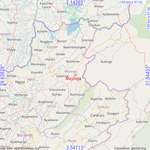
Muyinga GPS coordinates[2]
2° 50' 42.36" South, 30° 20' 29.04" East
| Map corner | latitude | longitude |
|---|---|---|
| Upper-left | -2.14265°, | 29.63828° |
| Center: | -2.8451°, | 30.3414° |
| Lower-right: | -3.54713°, | 31.04453° |
| Map W x H: | 156.2×156.2 km | = 97.1×97.1mi |
| max Lat: | -2.5845° ⇑5% North |
| Muyinga: | -2.8451° |
| min Lat: | ⇓95% South -4.1348° |
| min Long | Muyinga | max Long |
| 29.1248° | 30.3414° | 30.5528° |
| W 95%⇐ | ⇒5% E |
Elevation
Elevation of Muyinga is 1757 m = 5764 ft, and this is 245.6 m = 806 ft above average elevation for this country.
| Max E: |
2054 m = 6739 ft | 40% |
| Muyinga | 1757 m 5764 ft | |
| Avg. | 1511.4 m = 4959 ft | |
Min E: |
790 m = 2592 ft | 60% |
See also: Muyinga elevation on elevation.city.
Geographical zone
Muyinga is located in South Torrid zone (between Equator and Tropic of Capricorn). Distance of Equator is 316.3 km =196.5 mi to North.| Distance of | km | miles | from Muyinga |
|---|---|---|---|
| Equator | 316.3 | 196.5 | to North |
| Tropic Capricorn | 2289.6 | 1422.7 | to South |
| Antarctic Circle | 7084.8 | 4402.3 | to South |
| South Pole | 9690.7 | 6021.5 | to South |


Nearby cities:
15 places around Muyinga: (largest is in red/bold)
• Bubanza
108.7 km =67.5 mi,  256°
256°
• Bujumbura
124.1 km =77.1 mi,  241°
241°
• Cankuzo
47.7 km =29.6 mi,  150°
150°
• Gitega
79.6 km =49.5 mi,  215°
215°
• Isale
110.5 km =68.7 mi, 239°
• Karuzi
34.7 km =21.6 mi,  214°
214°
• Kayanza
79.5 km =49.4 mi, 263°
• Kirundo
39.8 km =24.7 mi,  316°
316°
• Manga
121.7 km =75.6 mi,  232°
232°
• Muramvya
94.1 km =58.5 mi, 239°
• Muzinda
112.2 km =69.7 mi,  245°
245°
• Mwaro
102.5 km =63.7 mi, 223°
• Ngozi
57.1 km =35.5 mi, 263°
• Rutana
126.5 km =78.6 mi,  197°
197°
• Ruyigi
70.9 km =44.1 mi,  188°
188°
Sources, notices
• [Note1] Compared only with cities in Burundi existing in our database
• [Src1] Map data: © OpenStreetMap contributors (CC-BY-SA)
• [Src2] Other city data from geonames.org with taken over terms of usage.
• [Src3] Geographical zone / Annual Mean Temperature by Robert A. Rohde @ Wikipedia
