Cankuzo geodata
Cankuzo is a seat of a first-order administrative division; located in Burundi in Africa/Bujumbura (GMT+2) time zone. With population of 6,585 people, there are 13 cities with bigger population in this country. Compared to other cities in Burundi, 60% of cities are located further ↓South; 100% of cities are located further ←West and 55% of cities have higher elevation than Cankuzo. Note1


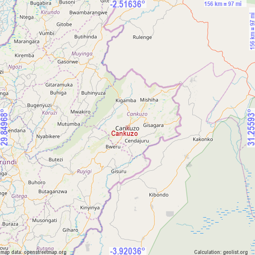
Cankuzo GPS coordinates[2]
3° 13' 6.96" South, 30° 33' 10.08" East
| Map corner | latitude | longitude |
|---|---|---|
| Upper-left | -2.51636°, | 29.84968° |
| Center: | -3.2186°, | 30.5528° |
| Lower-right: | -3.92036°, | 31.25593° |
| Map W x H: | 156.1×156.1 km | = 97×97mi |
| max Lat: | -2.5845° ⇑40% North |
| Cankuzo: | -3.2186° |
| min Lat: | ⇓60% South -4.1348° |
| min Long | Cankuzo | max Long |
| 29.1248° | 30.5528° | 30.5528° |
| W 100%⇐ | ⇒0% E |
Elevation
Elevation of Cankuzo is 1616 m = 5302 ft, and this is 104.6 m = 343 ft above average elevation for this country.
| Max E: |
2054 m = 6739 ft | 55% |
| Cankuzo | 1616 m 5302 ft | |
| Avg. | 1511.4 m = 4959 ft | |
Min E: |
790 m = 2592 ft | 45% |
See also: Burundi elevation on elevation.city.
Geographical zone
Cankuzo is located in South Torrid zone (between Equator and Tropic of Capricorn). Distance of Equator is 357.9 km =222.4 mi to North.| Distance of | km | miles | from Cankuzo |
|---|---|---|---|
| Equator | 357.9 | 222.4 | to North |
| Tropic Capricorn | 2248 | 1396.8 | to South |
| Antarctic Circle | 7043.3 | 4376.5 | to South |
| South Pole | 9649.2 | 5995.7 | to South |


Nearby cities:
15 places around Cankuzo: (largest is in red/bold)
• Bubanza
129.9 km =80.7 mi,  276°
276°
• Bururi
131.2 km =81.5 mi,  231°
231°
• Gitega
73.5 km =45.7 mi,  251°
251°
• Isale
119.5 km =74.3 mi,  263°
263°
• Karuzi
45.2 km =28.1 mi,  286°
286°
• Kayanza
107.7 km =66.9 mi, 287°
• Kirundo
86.9 km =54 mi,  324°
324°
• Manga
124.5 km =77.4 mi, 254°
• Muramvya
105 km =65.2 mi,  266°
266°
• Muyinga
47.7 km =29.6 mi,  330°
330°
• Muzinda
125.8 km =78.2 mi, 267°
• Mwaro
99.7 km =62 mi, 250°
• Ngozi
87.3 km =54.2 mi, 293°
• Rutana
100.5 km =62.4 mi,  218°
218°
• Ruyigi
44.3 km =27.5 mi, 229°
Sources, notices
• [Note1] Compared only with cities in Burundi existing in our database
• [Src1] Map data: © OpenStreetMap contributors (CC-BY-SA)
• [Src2] Other city data from geonames.org with taken over terms of usage.
• [Src3] Geographical zone / Annual Mean Temperature by Robert A. Rohde @ Wikipedia
