Kirundo geodata
Kirundo is a seat of a first-order administrative division; located in Burundi in Africa/Bujumbura (GMT+2) time zone. With population of 6,083 people, there are 14 cities with bigger population in this country. Compared to other cities in Burundi, 100% of cities are located further ↓South; 80% of cities are located further ←West and 70% of cities have higher elevation than Kirundo. Note1


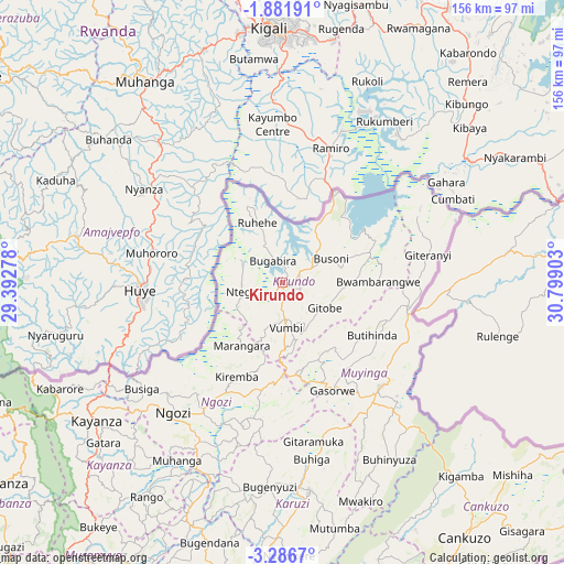
Kirundo GPS coordinates[2]
2° 35' 4.2" South, 30° 5' 45.24" East
| Map corner | latitude | longitude |
|---|---|---|
| Upper-left | -1.88191°, | 29.39278° |
| Center: | -2.5845°, | 30.0959° |
| Lower-right: | -3.2867°, | 30.79903° |
| Map W x H: | 156.2×156.2 km | = 97.1×97.1mi |
| max Lat: | -2.5845° ⇑0% North |
| Kirundo: | -2.5845° |
| min Lat: | ⇓100% South -4.1348° |
| min Long | Kirundo | max Long |
| 29.1248° | 30.0959° | 30.5528° |
| W 80%⇐ | ⇒20% E |
Elevation
Elevation of Kirundo is 1403 m = 4603 ft, and this is 108.4 m = 356 ft below average elevation for this country.
| Max E: |
2054 m = 6739 ft | 70% |
| Avg. | 1511.4 m = 4959 ft | |
| Kirundo | 1403 m = 4603 ft | |
Min E: |
790 m = 2592 ft | 30% |
See also: Burundi elevation on elevation.city.
Geographical zone
Kirundo is located in South Torrid zone (between Equator and Tropic of Capricorn). Distance of Equator is 287.4 km =178.6 mi to North.| Distance of | km | miles | from Kirundo |
|---|---|---|---|
| Equator | 287.4 | 178.6 | to North |
| Tropic Capricorn | 2318.5 | 1440.6 | to South |
| Antarctic Circle | 7113.8 | 4420.3 | to South |
| South Pole | 9719.7 | 6039.5 | to South |


Nearby cities:
15 places around Kirundo: (largest is in red/bold)
• Bubanza
95.8 km =59.5 mi,  234°
234°
• Buganda
108.7 km =67.5 mi,  247°
247°
• Bujumbura
120.5 km =74.9 mi,  222°
222°
• Cankuzo
86.9 km =54 mi,  144°
144°
• Cibitoke
113 km =70.2 mi, 252°
• Gitega
95.6 km =59.4 mi,  191°
191°
• Isale
108.8 km =67.6 mi, 218°
• Karuzi
58 km =36 mi,  172°
172°
• Kayanza
64 km =39.8 mi, 234°
• Muramvya
93.4 km =58 mi, 215°
• Muyinga
39.8 km =24.7 mi, 136°
• Muzinda
106.3 km =66.1 mi, 224°
• Mwaro
111.9 km =69.5 mi,  202°
202°
• Ngozi
46.5 km =28.9 mi, 219°
• Ruyigi
100.6 km =62.5 mi, 170°
Sources, notices
• [Note1] Compared only with cities in Burundi existing in our database
• [Src1] Map data: © OpenStreetMap contributors (CC-BY-SA)
• [Src2] Other city data from geonames.org with taken over terms of usage.
• [Src3] Geographical zone / Annual Mean Temperature by Robert A. Rohde @ Wikipedia
