Thimphu geodata
Thimphu is a capital of a political entity; located in Bhutan in Asia/Thimphu (GMT+6) time zone. With population of 98,676 people, there are 0 cities with bigger population in this country. Compared to other cities in Bhutan, 66.7% of cities are located further ↓South; 77.8% of cities are located further →East and 85.2% of cities have lower elevation than Thimphu. Note1


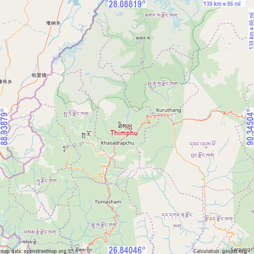
Thimphu GPS coordinates[2]
27° 27' 57.924" North, 89° 38' 30.876" East
| Map corner | latitude | longitude |
|---|---|---|
| Upper-left | 28.08819°, | 88.93879° |
| Center: | 27.46609°, | 89.64191° |
| Lower-right: | 26.84046°, | 90.34504° |
| Map W x H: | 138.7×138.7 km | = 86.2×86.2mi |
| max Lat: | 27.90372° ⇑33.3% North |
| Thimphu: | 27.46609° |
| min Lat: | ⇓66.7% South 26.78333° |
| min Long | Thimphu | max Long |
| 89.09951° | 89.64191° | 92.1° |
| W 22.2%⇐ | ⇒77.8% E |
Elevation
Elevation of Thimphu is 2307 m = 7569 ft, and this is 928.8 m = 3047 ft above average elevation for this country.
| Max E: |
2761 m = 9058 ft | 14.8% |
| Thimphu | 2307 m 7569 ft | |
| Avg. | 1378.2 m = 4522 ft | |
Min E: |
145 m = 476 ft | 85.2% |
See also: Thimphu elevation on elevation.city.
Geographical zone
Thimphu is located in North temperate zone (between Tropic of Cancer and the Arctic Circle). Distance of this Northern Tropic circle is 448 km =278.4 mi to South.| Distance of | km | miles | from Thimphu |
|---|---|---|---|
| North Pole | 6953.1 | 4320.5 | to North |
| Arctic Circle | 4347.2 | 2701.2 | to North |
| Tropic Cancer | 448 | 278.4 | to South |
| Equator | 3053.9 | 1897.6 | to South |


Nearby cities:
15 places around Thimphu: (largest is in red/bold)
• Daga
49.3 km =30.6 mi,  151°
151°
• Daphu
61.1 km =38 mi,  204°
204°
• Gasa
49.4 km =30.7 mi,  9°
9°
• Ha
36.7 km =22.8 mi,  256°
256°
• Lungtenzampa
0.3 km =0.2 mi,  46°
46°
• Pajo
25 km =15.5 mi,  72°
72°
• Paro
22.9 km =14.2 mi, 260°
• Phuntsholing
72.8 km =45.2 mi, 200°
• Punākha
27.1 km =16.8 mi,  59°
59°
• Samtse
82.8 km =51.4 mi,  220°
220°
• Sarpang
91.2 km =56.7 mi,  137°
137°
• Trongsa
85.4 km =53.1 mi,  87°
87°
• Tsimasham
42.1 km =26.2 mi,  194°
194°
• Tsirang
68.6 km =42.6 mi, 136°
• Wangdue Phodrang
25.5 km =15.8 mi,  84°
84°
Sources, notices
• [Note1] Compared only with cities in Bhutan existing in our database
• [Src1] Map data: © OpenStreetMap contributors (CC-BY-SA)
• [Src2] Other city data from geonames.org with taken over terms of usage.
• [Src3] Geographical zone / Annual Mean Temperature by Robert A. Rohde @ Wikipedia
