Daphu geodata
Daphu (Chukha) is a populated place; located in Bhutan in Asia/Thimphu (GMT+6) time zone. With population of 1,666 people, there are 17 cities with bigger population in this country. Compared to other cities in Bhutan, 70.4% of cities are located further ↑North; 92.6% of cities are located further →East and 70.4% of cities have higher elevation than Daphu. Note1


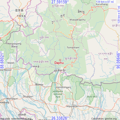
Daphu GPS coordinates[2]
26° 58' 0.012" North, 89° 22' 59.988" East
| Map corner | latitude | longitude |
|---|---|---|
| Upper-left | 27.59159°, | 88.68021° |
| Center: | 26.96667°, | 89.38333° |
| Lower-right: | 26.33826°, | 90.08646° |
| Map W x H: | 139.4×139.4 km | = 86.6×86.6mi |
| max Lat: | 27.90372° ⇑70.4% North |
| Daphu: | 26.96667° |
| min Lat: | ⇓29.6% South 26.78333° |
| min Long | Daphu | max Long |
| 89.09951° | 89.38333° | 92.1° |
| W 7.4%⇐ | ⇒92.6% E |
Elevation
Elevation of Daphu is 914 m = 2999 ft, and this is 464.2 m = 1523 ft below average elevation for this country.
| Max E: |
2761 m = 9058 ft | 70.4% |
| Avg. | 1378.2 m = 4522 ft | |
| Daphu | 914 m = 2999 ft | |
Min E: |
145 m = 476 ft | 29.6% |
See also: Bhutan elevation on elevation.city.
Geographical zone
Daphu is located in North temperate zone (between Tropic of Cancer and the Arctic Circle). Distance of this Northern Tropic circle is 392.5 km =243.9 mi to South.| Distance of | km | miles | from Daphu |
|---|---|---|---|
| North Pole | 7008.6 | 4354.9 | to North |
| Arctic Circle | 4402.8 | 2735.8 | to North |
| Tropic Cancer | 392.5 | 243.9 | to South |
| Equator | 2998.4 | 1863.1 | to South |


Nearby cities:
15 places around Daphu: (largest is in red/bold)
• Daga
50.4 km =31.3 mi,  76°
76°
• Gasa
109.6 km =68.1 mi,  18°
18°
• Ha
47.9 km =29.8 mi,  347°
347°
• Lungtenzampa
61.5 km =38.2 mi, 24°
• Pajo
80.1 km =49.8 mi,  38°
38°
• Paro
51.7 km =32.1 mi,  3°
3°
• Phuntsholing
12.8 km =8 mi,  177°
177°
• Punākha
84.9 km =52.8 mi, 35°
• Samtse
29.1 km =18.1 mi,  255°
255°
• Sarpang
88.4 km =54.9 mi,  97°
97°
• Thimphu
61.1 km =38 mi, 24°
• Trongsa
126.1 km =78.4 mi,  61°
61°
• Tsimasham
21.1 km =13.1 mi,  45°
45°
• Tsirang
73.5 km =45.7 mi,  85°
85°
• Wangdue Phodrang
77.1 km =47.9 mi, 41°
Sources, notices
• [Note1] Compared only with cities in Bhutan existing in our database
• [Src1] Map data: © OpenStreetMap contributors (CC-BY-SA)
• [Src2] Other city data from geonames.org with taken over terms of usage.
• [Src3] Geographical zone / Annual Mean Temperature by Robert A. Rohde @ Wikipedia
