Tsirang geodata
Tsirang (Chirang) is a seat of a first-order administrative division; located in Bhutan in Asia/Thimphu (GMT+6) time zone. With population of 18,667 people, there are 2 cities with bigger population in this country. Compared to other cities in Bhutan, 66.7% of cities are located further ↑North; 51.9% of cities are located further →East and 51.9% of cities have lower elevation than Tsirang. Note1


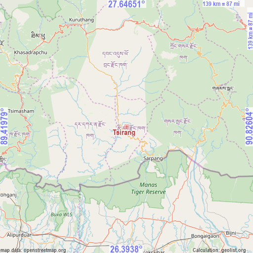
Tsirang GPS coordinates[2]
27° 1' 18.84" North, 90° 7' 22.476" East
| Map corner | latitude | longitude |
|---|---|---|
| Upper-left | 27.64651°, | 89.41979° |
| Center: | 27.0219°, | 90.12291° |
| Lower-right: | 26.3938°, | 90.82604° |
| Map W x H: | 139.3×139.3 km | = 86.6×86.6mi |
| max Lat: | 27.90372° ⇑66.7% North |
| Tsirang: | 27.0219° |
| min Lat: | ⇓33.3% South 26.78333° |
| min Long | Tsirang | max Long |
| 89.09951° | 90.12291° | 92.1° |
| W 48.1%⇐ | ⇒51.9% E |
Elevation
Elevation of Tsirang is 1410 m = 4626 ft, and this is 31.8 m = 104 ft above average elevation for this country.
| Max E: |
2761 m = 9058 ft | 48.1% |
| Tsirang | 1410 m 4626 ft | |
| Avg. | 1378.2 m = 4522 ft | |
Min E: |
145 m = 476 ft | 51.9% |
See also: Bhutan elevation on elevation.city.
Geographical zone
Tsirang is located in North temperate zone (between Tropic of Cancer and the Arctic Circle). Distance of this Northern Tropic circle is 398.6 km =247.7 mi to South.| Distance of | km | miles | from Tsirang |
|---|---|---|---|
| North Pole | 7002.5 | 4351.2 | to North |
| Arctic Circle | 4396.6 | 2731.9 | to North |
| Tropic Cancer | 398.6 | 247.7 | to South |
| Equator | 3004.6 | 1867 | to South |


Nearby cities:
15 places around Tsirang: (largest is in red/bold)
• Daga
25.1 km =15.6 mi,  283°
283°
• Daphu
73.5 km =45.7 mi,  265°
265°
• Jakar
85.5 km =53.1 mi,  46°
46°
• Lungtenzampa
68.6 km =42.6 mi,  316°
316°
• Pajo
61.6 km =38.3 mi,  337°
337°
• Panbang
87 km =54.1 mi,  101°
101°
• Paro
83.6 km =51.9 mi,  302°
302°
• Phuntsholing
75.2 km =46.7 mi,  255°
255°
• Punākha
67.8 km =42.1 mi, 339°
• Sarpang
22.7 km =14.1 mi,  140°
140°
• Shemgang
57.2 km =35.5 mi,  67°
67°
• Thimphu
68.6 km =42.6 mi, 316°
• Trongsa
65.6 km =40.8 mi,  35°
35°
• Tsimasham
58.7 km =36.5 mi, 278°
• Wangdue Phodrang
56.2 km =34.9 mi, 336°
Sources, notices
• [Note1] Compared only with cities in Bhutan existing in our database
• [Src1] Map data: © OpenStreetMap contributors (CC-BY-SA)
• [Src2] Other city data from geonames.org with taken over terms of usage.
• [Src3] Geographical zone / Annual Mean Temperature by Robert A. Rohde @ Wikipedia
