Punākha geodata
Punākha (Punakha) is a seat of a first-order administrative division; located in Bhutan in Asia/Thimphu (GMT+6) time zone. With population of 21,500 people, there is 1 city with bigger population in this country. Compared to other cities in Bhutan, 88.9% of cities are located further ↓South; 63% of cities are located further →East and 55.6% of cities have higher elevation than Punākha. Note1


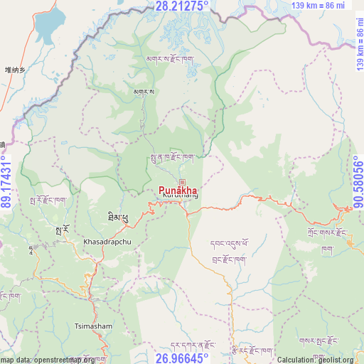
Punākha GPS coordinates[2]
27° 35' 28.932" North, 89° 52' 38.748" East
| Map corner | latitude | longitude |
|---|---|---|
| Upper-left | 28.21275°, | 89.17431° |
| Center: | 27.59137°, | 89.87743° |
| Lower-right: | 26.96645°, | 90.58056° |
| Map W x H: | 138.6×138.6 km | = 86.1×86.1mi |
| max Lat: | 27.90372° ⇑11.1% North |
| Punākha: | 27.59137° |
| min Lat: | ⇓88.9% South 26.78333° |
| min Long | Punākha | max Long |
| 89.09951° | 89.87743° | 92.1° |
| W 37%⇐ | ⇒63% E |
Elevation
Elevation of Punākha is 1293 m = 4242 ft, and this is 85.2 m = 280 ft below average elevation for this country.
| Max E: |
2761 m = 9058 ft | 55.6% |
| Avg. | 1378.2 m = 4522 ft | |
| Punākha | 1293 m = 4242 ft | |
Min E: |
145 m = 476 ft | 44.4% |
See also: Bhutan elevation on elevation.city.
Geographical zone
Punākha is located in North temperate zone (between Tropic of Cancer and the Arctic Circle). Distance of this Northern Tropic circle is 462 km =287.1 mi to South.| Distance of | km | miles | from Punākha |
|---|---|---|---|
| North Pole | 6939.2 | 4311.8 | to North |
| Arctic Circle | 4333.3 | 2692.6 | to North |
| Tropic Cancer | 462 | 287.1 | to South |
| Equator | 3067.9 | 1906.3 | to South |


Nearby cities:
15 places around Punākha: (largest is in red/bold)
• Daga
57.4 km =35.7 mi,  180°
180°
• Daphu
84.9 km =52.8 mi,  215°
215°
• Gasa
37.8 km =23.5 mi,  336°
336°
• Ha
63.1 km =39.2 mi,  248°
248°
• Jakar
86.4 km =53.7 mi,  93°
93°
• Lungtenzampa
26.7 km =16.6 mi,  239°
239°
• Pajo
6.5 km =4 mi,  174°
174°
• Paro
49.1 km =30.5 mi, 248°
• Sarpang
89.6 km =55.7 mi,  154°
154°
• Shemgang
87.6 km =54.4 mi,  118°
118°
• Thimphu
27.1 km =16.8 mi, 239°
• Trongsa
62.9 km =39.1 mi,  99°
99°
• Tsimasham
64.3 km =40 mi,  211°
211°
• Tsirang
67.8 km =42.1 mi,  159°
159°
• Wangdue Phodrang
11.9 km =7.4 mi, 169°
In other languages:
- In Spanish: Distrito de Punakha
- In German: Punakha
- In Russian: Пунакха
- In Chinese: 普那卡
Sources, notices
• [Note1] Compared only with cities in Bhutan existing in our database
• [Src1] Map data: © OpenStreetMap contributors (CC-BY-SA)
• [Src2] Other city data from geonames.org with taken over terms of usage.
• [Src3] Geographical zone / Annual Mean Temperature by Robert A. Rohde @ Wikipedia
