Gasa geodata
Gasa is a seat of a first-order administrative division; located in Bhutan in Asia/Thimphu (GMT+6) time zone. With population of 548 people, there are 25 cities with bigger population in this country. Compared to other cities in Bhutan, 100% of cities are located further ↓South; 70.4% of cities are located further →East and 100% of cities have lower elevation than Gasa. Note1


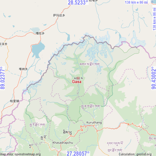
Gasa GPS coordinates[2]
27° 54' 13.392" North, 89° 43' 36.804" East
| Map corner | latitude | longitude |
|---|---|---|
| Upper-left | 28.5233°, | 89.02377° |
| Center: | 27.90372°, | 89.72689° |
| Lower-right: | 27.28057°, | 90.43002° |
| Map W x H: | 138.2×138.2 km | = 85.9×85.9mi |
| max Lat: | 27.90372° ⇑0% North |
| Gasa: | 27.90372° |
| min Lat: | ⇓100% South 26.78333° |
| min Long | Gasa | max Long |
| 89.09951° | 89.72689° | 92.1° |
| W 29.6%⇐ | ⇒70.4% E |
Elevation
Elevation of Gasa is 2761 m = 9058 ft, and this is 1382.8 m = 4537 ft above average elevation for this country.
| Max E: |
2761 m = 9058 ft | 0% |
| Gasa | 2761 m 9058 ft | |
| Avg. | 1378.2 m = 4522 ft | |
Min E: |
145 m = 476 ft | 100% |
See also: Bhutan elevation on elevation.city.
Geographical zone
Gasa is located in North temperate zone (between Tropic of Cancer and the Arctic Circle). Distance of this Northern Tropic circle is 496.7 km =308.6 mi to South.| Distance of | km | miles | from Gasa |
|---|---|---|---|
| North Pole | 6904.5 | 4290.3 | to North |
| Arctic Circle | 4298.6 | 2671 | to North |
| Tropic Cancer | 496.7 | 308.6 | to South |
| Equator | 3102.6 | 1927.9 | to South |


Nearby cities:
15 places around Gasa: (largest is in red/bold)
• Daga
93.3 km =58 mi,  170°
170°
• Daphu
109.6 km =68.1 mi,  198°
198°
• Ha
72.3 km =44.9 mi,  217°
217°
• Jakar
108.4 km =67.4 mi,  111°
111°
• Lungtenzampa
49.1 km =30.5 mi,  189°
189°
• Pajo
44 km =27.3 mi,  159°
159°
• Paro
61 km =37.9 mi,  210°
210°
• Phuntsholing
121.7 km =75.6 mi, 195°
• Punākha
37.8 km =23.5 mi, 156°
• Shemgang
119.4 km =74.2 mi,  129°
129°
• Thimphu
49.4 km =30.7 mi, 189°
• Trongsa
88.8 km =55.2 mi,  120°
120°
• Tsimasham
91.4 km =56.8 mi, 191°
• Tsirang
105.5 km =65.6 mi, 158°
• Wangdue Phodrang
49.4 km =30.7 mi, 159°
Sources, notices
• [Note1] Compared only with cities in Bhutan existing in our database
• [Src1] Map data: © OpenStreetMap contributors (CC-BY-SA)
• [Src2] Other city data from geonames.org with taken over terms of usage.
• [Src3] Geographical zone / Annual Mean Temperature by Robert A. Rohde @ Wikipedia
