Paro geodata
Paro is a seat of a first-order administrative division; located in Bhutan in Asia/Thimphu (GMT+6) time zone. With population of 2,169 people, there are 16 cities with bigger population in this country. Compared to other cities in Bhutan, 63% of cities are located further ↓South; 85.2% of cities are located further →East and 81.5% of cities have lower elevation than Paro. Note1


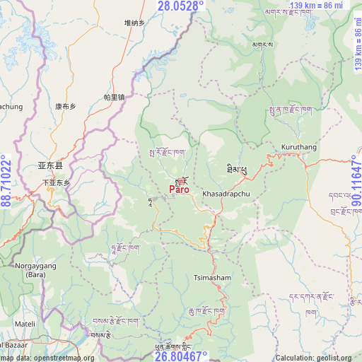
Paro GPS coordinates[2]
27° 25' 49.8" North, 89° 24' 48.024" East
| Map corner | latitude | longitude |
|---|---|---|
| Upper-left | 28.0528°, | 88.71022° |
| Center: | 27.4305°, | 89.41334° |
| Lower-right: | 26.80467°, | 90.11647° |
| Map W x H: | 138.8×138.8 km | = 86.2×86.2mi |
| max Lat: | 27.90372° ⇑37% North |
| Paro: | 27.4305° |
| min Lat: | ⇓63% South 26.78333° |
| min Long | Paro | max Long |
| 89.09951° | 89.41334° | 92.1° |
| W 14.8%⇐ | ⇒85.2% E |
Elevation
Elevation of Paro is 2266 m = 7434 ft, and this is 887.8 m = 2913 ft above average elevation for this country.
| Max E: |
2761 m = 9058 ft | 18.5% |
| Paro | 2266 m 7434 ft | |
| Avg. | 1378.2 m = 4522 ft | |
Min E: |
145 m = 476 ft | 81.5% |
See also: Bhutan elevation on elevation.city.
Geographical zone
Paro is located in North temperate zone (between Tropic of Cancer and the Arctic Circle). Distance of this Northern Tropic circle is 444.1 km =276 mi to South.| Distance of | km | miles | from Paro |
|---|---|---|---|
| North Pole | 6957.1 | 4322.9 | to North |
| Arctic Circle | 4351.2 | 2703.7 | to North |
| Tropic Cancer | 444.1 | 276 | to South |
| Equator | 3050 | 1895.2 | to South |


Nearby cities:
15 places around Paro: (largest is in red/bold)
• Daga
60.5 km =37.6 mi,  130°
130°
• Daphu
51.7 km =32.1 mi,  183°
183°
• Gasa
61 km =37.9 mi,  30°
30°
• Ha
13.9 km =8.6 mi,  249°
249°
• Lungtenzampa
23.2 km =14.4 mi,  79°
79°
• Pajo
47.8 km =29.7 mi, 76°
• Phuntsholing
64.4 km =40 mi, 182°
• Punākha
49.1 km =30.5 mi,  68°
68°
• Samtse
66.8 km =41.5 mi,  207°
207°
• Sarpang
105.4 km =65.5 mi, 126°
• Thimphu
22.9 km =14.2 mi, 80°
• Trongsa
108.2 km =67.2 mi,  85°
85°
• Tsimasham
38.8 km =24.1 mi,  161°
161°
• Tsirang
83.6 km =51.9 mi,  122°
122°
• Wangdue Phodrang
48.3 km =30 mi, 82°
Sources, notices
• [Note1] Compared only with cities in Bhutan existing in our database
• [Src1] Map data: © OpenStreetMap contributors (CC-BY-SA)
• [Src2] Other city data from geonames.org with taken over terms of usage.
• [Src3] Geographical zone / Annual Mean Temperature by Robert A. Rohde @ Wikipedia
