Bokspits geodata
Bokspits is a populated place; located in Botswana in Africa/Gaborone (GMT+2) time zone. With population of 547 people, there are 102 cities with bigger population in this country. Compared to other cities in Botswana, 100% of cities are located further ↑North; 99% of cities are located further →East and 92.4% of cities have higher elevation than Bokspits. Note1


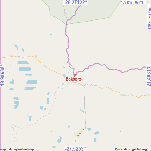
Bokspits GPS coordinates[2]
26° 54' 0" South, 20° 42' 0" East
| Map corner | latitude | longitude |
|---|---|---|
| Upper-left | -26.27122°, | 19.99688° |
| Center: | -26.9°, | 20.7° |
| Lower-right: | -27.5253°, | 21.40313° |
| Map W x H: | 139.4×139.4 km | = 86.6×86.6mi |
| max Lat: | -17.80165° ⇑100% North |
| Bokspits: | -26.9° |
| min Lat: | ⇓0% South -26.9° |
| min Long | Bokspits | max Long |
| 20.06667° | 20.7° | 28.74946° |
| W 1%⇐ | ⇒99% E |
Elevation
Elevation of Bokspits is 852 m = 2795 ft, and this is 163 m = 535 ft below average elevation for this country.
| Max E: |
1406 m = 4613 ft | 92.4% |
| Avg. | 1015 m = 3330 ft | |
| Bokspits | 852 m = 2795 ft | |
Min E: |
676 m = 2218 ft | 7.6% |
See also: Botswana elevation on elevation.city.
Geographical zone
Bokspits is located in South temperate zone (between Tropic of Capricorn and the Antarctic Circle). Distance of this Southern Tropic circle is 385.1 km =239.3 mi to North.| Distance of | km | miles | from Bokspits |
|---|---|---|---|
| Equator | 2991 | 1858.5 | to North |
| Tropic Capricorn | 385.1 | 239.3 | to North |
| Antarctic Circle | 4410.2 | 2740.4 | to South |
| South Pole | 7016.1 | 4359.6 | to South |


Nearby cities:
11 places around Bokspits: (largest is in red/bold)
• Hukuntsi
340.3 km =211.5 mi,  18°
18°
• Kang
415.4 km =258.1 mi,  30°
30°
• Khakhea
372.3 km =231.3 mi,  48°
48°
• Khuis
115.4 km =71.7 mi,  77°
77°
• Kuli
432.8 km =268.9 mi,  351°
351°
• Lehututu
346.5 km =215.3 mi, 19°
• Lokwabe
324.5 km =201.6 mi, 20°
• Manyana
402.4 km =250 mi,  14°
14°
• Tshabong
198.2 km =123.2 mi,  61°
61°
• Tshane
340.7 km =211.7 mi, 20°
• Werda
315.5 km =196 mi, 54°
Sources, notices
• [Note1] Compared only with cities in Botswana existing in our database
• [Src1] Map data: © OpenStreetMap contributors (CC-BY-SA)
• [Src2] Other city data from geonames.org with taken over terms of usage.
• [Src3] Geographical zone / Annual Mean Temperature by Robert A. Rohde @ Wikipedia
