Tshane geodata
Tshane (Kgalagadi) is a populated place; located in Botswana in Africa/Gaborone (GMT+2) time zone. With population of 969 people, there are 86 cities with bigger population in this country. Compared to other cities in Botswana, 64.8% of cities are located further ↑North; 91.4% of cities are located further →East and 79% of cities have lower elevation than Tshane. Note1


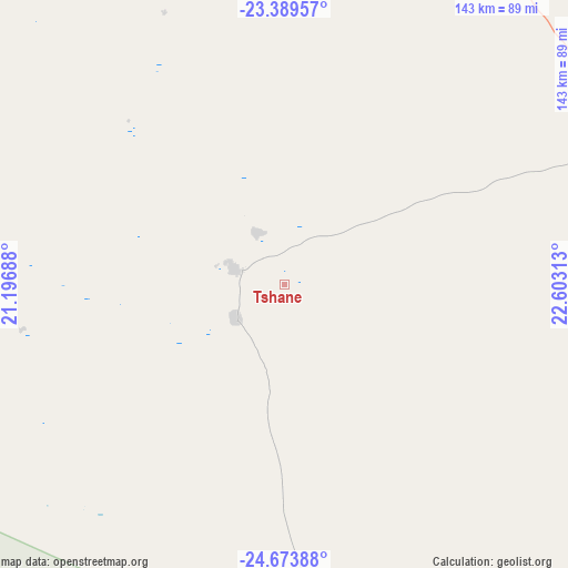
Tshane GPS coordinates[2]
24° 1' 59.988" South, 21° 54' 0" East
| Map corner | latitude | longitude |
|---|---|---|
| Upper-left | -23.38957°, | 21.19688° |
| Center: | -24.03333°, | 21.9° |
| Lower-right: | -24.67388°, | 22.60313° |
| Map W x H: | 142.8×142.8 km | = 88.7×88.7mi |
| max Lat: | -17.80165° ⇑64.8% North |
| Tshane: | -24.03333° |
| min Lat: | ⇓35.2% South -26.9° |
| min Long | Tshane | max Long |
| 20.06667° | 21.9° | 28.74946° |
| W 8.6%⇐ | ⇒91.4% E |
Elevation
Elevation of Tshane is 1118 m = 3668 ft, and this is 103 m = 338 ft above average elevation for this country.
| Max E: |
1406 m = 4613 ft | 21% |
| Tshane | 1118 m 3668 ft | |
| Avg. | 1015 m = 3330 ft | |
Min E: |
676 m = 2218 ft | 79% |
See also: Botswana elevation on elevation.city.
Geographical zone
Tshane is located in South temperate zone (between Tropic of Capricorn and the Antarctic Circle). Distance of this Southern Tropic circle is 66.3 km =41.2 mi to North.| Distance of | km | miles | from Tshane |
|---|---|---|---|
| Equator | 2672.3 | 1660.5 | to North |
| Tropic Capricorn | 66.3 | 41.2 | to North |
| Antarctic Circle | 4728.9 | 2938.4 | to South |
| South Pole | 7334.8 | 4557.6 | to South |


Nearby cities:
15 places around Tshane: (largest is in red/bold)
• Dekar
278 km =172.7 mi,  0°
0°
• Dutlwe
203.2 km =126.3 mi,  88°
88°
• Ghanzi
261 km =162.2 mi,  354°
354°
• Hukuntsi
12.8 km =8 mi,  287°
287°
• Kang
98.7 km =61.3 mi,  66°
66°
• Khakhea
177.2 km =110.1 mi,  114°
114°
• Khudumelapye
290.1 km =180.3 mi, 86°
• Khuis
292.9 km =182 mi,  181°
181°
• Kuli
216.5 km =134.5 mi,  300°
300°
• Lehututu
8.1 km =5 mi,  335°
335°
• Lokwabe
16.3 km =10.1 mi,  204°
204°
• Manyana
72.9 km =45.3 mi, 345°
• Sekoma
205.2 km =127.5 mi,  101°
101°
• Tshabong
231 km =143.5 mi,  166°
166°
• Werda
195.8 km =121.7 mi,  134°
134°
Sources, notices
• [Note1] Compared only with cities in Botswana existing in our database
• [Src1] Map data: © OpenStreetMap contributors (CC-BY-SA)
• [Src2] Other city data from geonames.org with taken over terms of usage.
• [Src3] Geographical zone / Annual Mean Temperature by Robert A. Rohde @ Wikipedia
