Hukuntsi geodata
Hukuntsi (Kgalagadi) is a populated place; located in Botswana in Africa/Gaborone (GMT+2) time zone. With population of 4,403 people, there are 34 cities with bigger population in this country. Compared to other cities in Botswana, 62.9% of cities are located further ↑North; 96.2% of cities are located further →East and 84.8% of cities have lower elevation than Hukuntsi. Note1


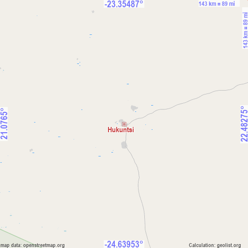
Hukuntsi GPS coordinates[2]
23° 59' 55.68" South, 21° 46' 46.632" East
| Map corner | latitude | longitude |
|---|---|---|
| Upper-left | -23.35487°, | 21.0765° |
| Center: | -23.9988°, | 21.77962° |
| Lower-right: | -24.63953°, | 22.48275° |
| Map W x H: | 142.8×142.8 km | = 88.7×88.7mi |
| max Lat: | -17.80165° ⇑62.9% North |
| Hukuntsi: | -23.9988° |
| min Lat: | ⇓37.1% South -26.9° |
| min Long | Hukuntsi | max Long |
| 20.06667° | 21.77962° | 28.74946° |
| W 3.8%⇐ | ⇒96.2% E |
Elevation
Elevation of Hukuntsi is 1141 m = 3743 ft, and this is 126 m = 413 ft above average elevation for this country.
| Max E: |
1406 m = 4613 ft | 15.2% |
| Hukuntsi | 1141 m 3743 ft | |
| Avg. | 1015 m = 3330 ft | |
Min E: |
676 m = 2218 ft | 84.8% |
See also: Botswana elevation on elevation.city.
Geographical zone
Hukuntsi is located in South temperate zone (between Tropic of Capricorn and the Antarctic Circle). Distance of this Southern Tropic circle is 62.5 km =38.8 mi to North.| Distance of | km | miles | from Hukuntsi |
|---|---|---|---|
| Equator | 2668.4 | 1658.1 | to North |
| Tropic Capricorn | 62.5 | 38.8 | to North |
| Antarctic Circle | 4732.8 | 2940.8 | to South |
| South Pole | 7338.6 | 4560 | to South |


Nearby cities:
15 places around Hukuntsi: (largest is in red/bold)
• Dekar
274.6 km =170.6 mi,  3°
3°
• Dutlwe
215.4 km =133.8 mi,  89°
89°
• Ghanzi
256.2 km =159.2 mi,  356°
356°
• Kang
108.6 km =67.5 mi,  70°
70°
• Khakhea
189.9 km =118 mi,  113°
113°
• Khudumelapye
302.1 km =187.7 mi, 87°
• Khuis
296.7 km =184.4 mi,  178°
178°
• Kuli
204 km =126.8 mi,  301°
301°
• Lehututu
9.5 km =5.9 mi, 68°
• Lokwabe
19.4 km =12.1 mi,  163°
163°
• Manyana
66.9 km =41.6 mi,  354°
354°
• Sekoma
218 km =135.5 mi,  101°
101°
• Tshabong
237.9 km =147.8 mi, 163°
• Tshane
12.8 km =8 mi, 107°
• Werda
207.3 km =128.8 mi,  132°
132°
Sources, notices
• [Note1] Compared only with cities in Botswana existing in our database
• [Src1] Map data: © OpenStreetMap contributors (CC-BY-SA)
• [Src2] Other city data from geonames.org with taken over terms of usage.
• [Src3] Geographical zone / Annual Mean Temperature by Robert A. Rohde @ Wikipedia
