Kang geodata
Kang (Kgalagadi) is a populated place; located in Botswana in Africa/Gaborone (GMT+2) time zone. With population of 4,229 people, there are 35 cities with bigger population in this country. Compared to other cities in Botswana, 58.1% of cities are located further ↑North; 85.7% of cities are located further →East and 82.9% of cities have lower elevation than Kang. Note1


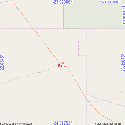
Kang GPS coordinates[2]
23° 40' 30.648" South, 22° 47' 15.432" East
| Map corner | latitude | longitude |
|---|---|---|
| Upper-left | -23.02966°, | 22.0845° |
| Center: | -23.67518°, | 22.78762° |
| Lower-right: | -24.31753°, | 23.49075° |
| Map W x H: | 143.2×143.2 km | = 89×89mi |
| max Lat: | -17.80165° ⇑58.1% North |
| Kang: | -23.67518° |
| min Lat: | ⇓41.9% South -26.9° |
| min Long | Kang | max Long |
| 20.06667° | 22.78762° | 28.74946° |
| W 14.3%⇐ | ⇒85.7% E |
Elevation
Elevation of Kang is 1139 m = 3737 ft, and this is 124 m = 407 ft above average elevation for this country.
| Max E: |
1406 m = 4613 ft | 17.1% |
| Kang | 1139 m 3737 ft | |
| Avg. | 1015 m = 3330 ft | |
Min E: |
676 m = 2218 ft | 82.9% |
See also: Botswana elevation on elevation.city.
Geographical zone
Kang is located in South temperate zone (between Tropic of Capricorn and the Antarctic Circle). Distance of this Southern Tropic circle is 26.5 km =16.5 mi to North.| Distance of | km | miles | from Kang |
|---|---|---|---|
| Equator | 2632.4 | 1635.7 | to North |
| Tropic Capricorn | 26.5 | 16.5 | to North |
| Antarctic Circle | 4768.7 | 2963.1 | to South |
| South Pole | 7374.6 | 4582.4 | to South |


Nearby cities:
15 places around Kang: (largest is in red/bold)
• Dekar
253.8 km =157.7 mi,  339°
339°
• Dutlwe
118.2 km =73.4 mi,  106°
106°
• Ghanzi
249.1 km =154.8 mi,  331°
331°
• Hukuntsi
108.6 km =67.5 mi,  250°
250°
• Jwaneng
222.2 km =138.1 mi,  117°
117°
• Khakhea
133.6 km =83 mi,  147°
147°
• Khudumelapye
201 km =124.9 mi,  96°
96°
• Lehututu
99.1 km =61.6 mi, 250°
• Letlhakeng
232.7 km =144.6 mi, 101°
• Lokwabe
111.3 km =69.2 mi,  240°
240°
• Manyana
113.4 km =70.5 mi,  285°
285°
• Sekoma
137.4 km =85.4 mi,  125°
125°
• Tshabong
266.2 km =165.4 mi,  187°
187°
• Tshane
98.7 km =61.3 mi, 246°
• Werda
183.9 km =114.3 mi,  164°
164°
Sources, notices
• [Note1] Compared only with cities in Botswana existing in our database
• [Src1] Map data: © OpenStreetMap contributors (CC-BY-SA)
• [Src2] Other city data from geonames.org with taken over terms of usage.
• [Src3] Geographical zone / Annual Mean Temperature by Robert A. Rohde @ Wikipedia
