Melita geodata
Melita (Manitoba) is a populated place; located in Canada in America/Winnipeg (GMT-5) time zone. With population of 1,167 people, there are 965 cities with bigger population in this country. Compared to other cities in Canada, 67.4% of cities are located further ↓South; 69% of cities are located further →East and 79.9% of cities have lower elevation than Melita. Note1


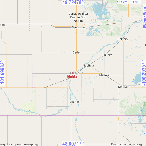
Melita GPS coordinates[2]
49° 16' 5.196" North, 100° 59' 48.084" West
| Map corner | latitude | longitude |
|---|---|---|
| Upper-left | 49.72478°, | -101.69982° |
| Center: | 49.26811°, | -100.99669° |
| Lower-right: | 48.80717°, | -100.29357° |
| Map W x H: | 102×102 km | = 63.4×63.4mi |
| max Lat: | 73.03752° ⇑32.6% North |
| Melita: | 49.26811° |
| min Lat: | ⇓67.4% South 42.05009° |
| min Long | Melita | max Long |
| -139.43328° | -100.99669° | -52.70931° |
| W 31%⇐ | ⇒69% E |
Elevation
Elevation of Melita is 443 m = 1453 ft, and this is 188.6 m = 619 ft above average elevation for this country.
| Max E: |
1518 m = 4980 ft | 20.1% |
| Melita | 443 m 1453 ft | |
| Avg. | 254.4 m = 835 ft | |
Min E: |
-2 m = -7 ft | 79.9% |
See also: Canada elevation on elevation.city.
Geographical zone
Melita is located in North temperate zone (between Tropic of Cancer and the Arctic Circle). Distance of this North polar circle is 1923.1 km =1195 mi to North.| Distance of | km | miles | from Melita |
|---|---|---|---|
| North Pole | 4529 | 2814.2 | to North |
| Arctic Circle | 1923.1 | 1195 | to North |
| Tropic Cancer | 2872.2 | 1784.7 | to South |
| Equator | 5478.1 | 3403.9 | to South |


Nearby cities:
15 places around Melita: (largest is in red/bold)
• Boissevain
68.4 km =42.5 mi,  93°
93°
• Brandon
99 km =61.5 mi,  49°
49°
• Carberry
135.6 km =84.3 mi,  60°
60°
• Carlyle
100.4 km =62.4 mi,  293°
293°
• Carnduff
59.5 km =37 mi,  259°
259°
• Deloraine
37.4 km =23.2 mi,  103°
103°
• Estevan
145.2 km =90.2 mi, 264°
• Killarney
97.3 km =60.5 mi, 95°
• Minnedosa
136.6 km =84.9 mi,  37°
37°
• Moosomin
107.6 km =66.9 mi,  333°
333°
• Oxbow
85.1 km =52.9 mi,  267°
267°
• Rivers
100.8 km =62.6 mi,  32°
32°
• Shilo
115.2 km =71.6 mi, 58°
• Souris
65.8 km =40.9 mi, 53°
• Virden
65 km =40.4 mi,  4°
4°
Sources, notices
• [Note1] Compared only with cities in Canada existing in our database
• [Src1] Map data: © OpenStreetMap contributors (CC-BY-SA)
• [Src2] Other city data from geonames.org with taken over terms of usage.
• [Src3] Geographical zone / Annual Mean Temperature by Robert A. Rohde @ Wikipedia
