Carnduff geodata
Carnduff (Saskatchewan) is a populated place; located in Canada in America/Regina (GMT-6) time zone. With population of 950 people, there are 1063 cities with bigger population in this country. Compared to other cities in Canada, 65.1% of cities are located further ↓South; 69.6% of cities are located further →East and 82.9% of cities have lower elevation than Carnduff. Note1


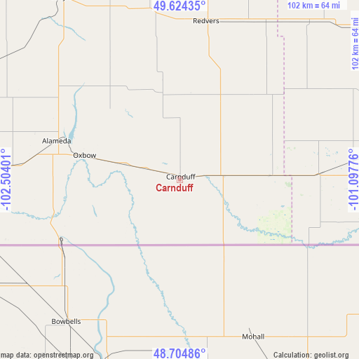
Carnduff GPS coordinates[2]
49° 10' 0.264" North, 101° 48' 3.168" West
| Map corner | latitude | longitude |
|---|---|---|
| Upper-left | 49.62435°, | -102.50401° |
| Center: | 49.16674°, | -101.80088° |
| Lower-right: | 48.70486°, | -101.09776° |
| Map W x H: | 102.2×102.2 km | = 63.5×63.5mi |
| max Lat: | 73.03752° ⇑34.9% North |
| Carnduff: | 49.16674° |
| min Lat: | ⇓65.1% South 42.05009° |
| min Long | Carnduff | max Long |
| -139.43328° | -101.80088° | -52.70931° |
| W 30.4%⇐ | ⇒69.6% E |
Elevation
Elevation of Carnduff is 520 m = 1706 ft, and this is 265.6 m = 871 ft above average elevation for this country.
| Max E: |
1518 m = 4980 ft | 17.1% |
| Carnduff | 520 m 1706 ft | |
| Avg. | 254.4 m = 835 ft | |
Min E: |
-2 m = -7 ft | 82.9% |
See also: Canada elevation on elevation.city.
Geographical zone
Carnduff is located in North temperate zone (between Tropic of Cancer and the Arctic Circle). Distance of this North polar circle is 1934.3 km =1201.9 mi to North.| Distance of | km | miles | from Carnduff |
|---|---|---|---|
| North Pole | 4540.2 | 2821.1 | to North |
| Arctic Circle | 1934.3 | 1201.9 | to North |
| Tropic Cancer | 2860.9 | 1777.7 | to South |
| Equator | 5466.8 | 3396.9 | to South |


Nearby cities:
15 places around Carnduff: (largest is in red/bold)
• Boissevain
127 km =78.9 mi,  86°
86°
• Brandon
153.4 km =95.3 mi,  60°
60°
• Carlyle
61.9 km =38.5 mi,  326°
326°
• Deloraine
95 km =59 mi, 88°
• Estevan
86.1 km =53.5 mi,  267°
267°
• Grenfell
161 km =100 mi, 329°
• Killarney
155.4 km =96.6 mi, 89°
• Kipling
119.9 km =74.5 mi, 329°
• Melita
59.5 km =37 mi,  79°
79°
• Moosomin
107.9 km =67 mi,  5°
5°
• Oxbow
27.7 km =17.2 mi,  285°
285°
• Rivers
147.9 km =91.9 mi,  49°
49°
• Souris
122.2 km =75.9 mi,  65°
65°
• Virden
98.6 km =61.3 mi,  39°
39°
• Weyburn
158.4 km =98.4 mi, 290°
Sources, notices
• [Note1] Compared only with cities in Canada existing in our database
• [Src1] Map data: © OpenStreetMap contributors (CC-BY-SA)
• [Src2] Other city data from geonames.org with taken over terms of usage.
• [Src3] Geographical zone / Annual Mean Temperature by Robert A. Rohde @ Wikipedia
