Manning geodata
Manning (Alberta) is a populated place; located in Canada in America/Edmonton (GMT-6) time zone. With population of 1,359 people, there are 899 cities with bigger population in this country. Compared to other cities in Canada, 97.4% of cities are located further ↓South; 85.7% of cities are located further →East and 80.6% of cities have lower elevation than Manning. Note1


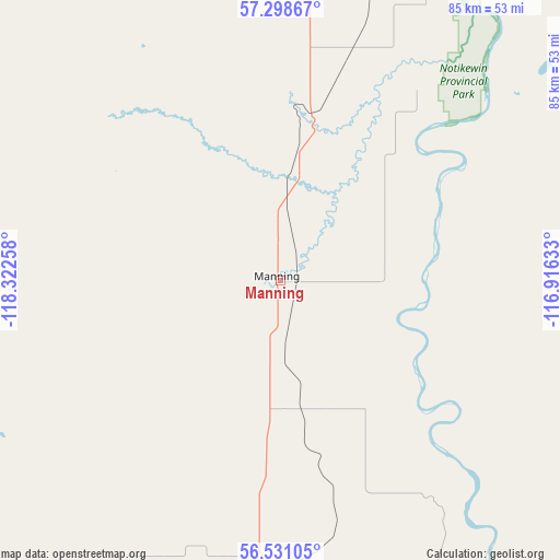
Manning GPS coordinates[2]
56° 55' 0.588" North, 117° 37' 10.02" West
| Map corner | latitude | longitude |
|---|---|---|
| Upper-left | 57.29867°, | -118.32258° |
| Center: | 56.91683°, | -117.61945° |
| Lower-right: | 56.53105°, | -116.91633° |
| Map W x H: | 85.4×85.3 km | = 53.1×53mi |
| max Lat: | 73.03752° ⇑2.6% North |
| Manning: | 56.91683° |
| min Lat: | ⇓97.4% South 42.05009° |
| min Long | Manning | max Long |
| -139.43328° | -117.61945° | -52.70931° |
| W 14.3%⇐ | ⇒85.7% E |
Elevation
Elevation of Manning is 475 m = 1558 ft, and this is 220.6 m = 724 ft above average elevation for this country.
| Max E: |
1518 m = 4980 ft | 19.4% |
| Manning | 475 m 1558 ft | |
| Avg. | 254.4 m = 835 ft | |
Min E: |
-2 m = -7 ft | 80.6% |
See also: Canada elevation on elevation.city.
Geographical zone
Manning is located in North temperate zone (between Tropic of Cancer and the Arctic Circle). Distance of this North polar circle is 1072.6 km =666.5 mi to North.| Distance of | km | miles | from Manning |
|---|---|---|---|
| North Pole | 3678.5 | 2285.7 | to North |
| Arctic Circle | 1072.6 | 666.5 | to North |
| Tropic Cancer | 3722.6 | 2313.1 | to South |
| Equator | 6328.6 | 3932.4 | to South |


Nearby cities:
15 places around Manning: (largest is in red/bold)
• Dawson Creek
206.5 km =128.3 mi,  231°
231°
• Fairview
105.6 km =65.6 mi,  206°
206°
• Falher
134.1 km =83.3 mi,  168°
168°
• Fort St. John
211.4 km =131.4 mi,  249°
249°
• Grande Prairie
208 km =129.2 mi,  200°
200°
• Grimshaw
81.6 km =50.7 mi,  179°
179°
• High Level
180.2 km =112 mi,  9°
9°
• High Prairie
179.2 km =111.3 mi,  156°
156°
• Paddle Prairie
115.2 km =71.6 mi,  3°
3°
• Peace River
78.2 km =48.6 mi, 165°
• Sexsmith
188.6 km =117.2 mi, 202°
• Spirit River
146.6 km =91.1 mi, 210°
• Valleyview
206.8 km =128.5 mi, 174°
• Wedgewood
212 km =131.7 mi, 199°
• Westlake
202.2 km =125.6 mi, 201°
Sources, notices
• [Note1] Compared only with cities in Canada existing in our database
• [Src1] Map data: © OpenStreetMap contributors (CC-BY-SA)
• [Src2] Other city data from geonames.org with taken over terms of usage.
• [Src3] Geographical zone / Annual Mean Temperature by Robert A. Rohde @ Wikipedia
