Lukolela geodata
Lukolela (Équateur) is a populated place; located in Democratic Republic of the Congo in Africa/Kinshasa (GMT+1) time zone. With population of 15,000 people, there are 68 cities with bigger population in this country. Compared to other cities in Democratic Republic of the Congo, 68.6% of cities are located further ↓South; 84.3% of cities are located further →East and 90% of cities have higher elevation than Lukolela. Note1


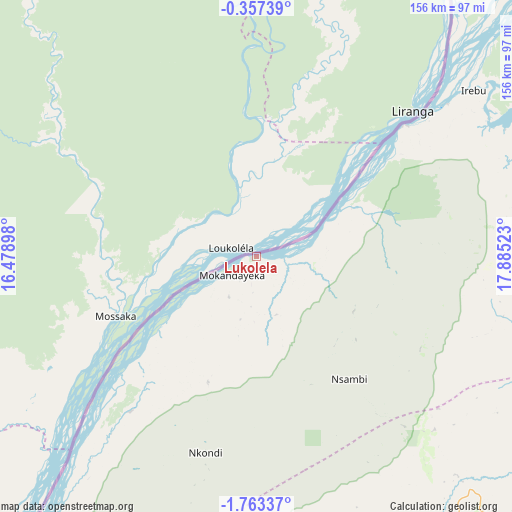
Lukolela GPS coordinates[2]
1° 3' 37.656" South, 17° 10' 55.56" East
| Map corner | latitude | longitude |
|---|---|---|
| Upper-left | -0.35739°, | 16.47898° |
| Center: | -1.06046°, | 17.1821° |
| Lower-right: | -1.76337°, | 17.88523° |
| Map W x H: | 156.3×156.3 km | = 97.1×97.1mi |
| max Lat: | 4.279° ⇑31.4% North |
| Lukolela: | -1.06046° |
| min Lat: | ⇓68.6% South -11.76097° |
| min Long | Lukolela | max Long |
| 12.37148° | 17.1821° | 30.25224° |
| W 15.7%⇐ | ⇒84.3% E |
Elevation
Elevation of Lukolela is 316 m = 1037 ft, and this is 340 m = 1115 ft below average elevation for this country.
| Max E: |
1996 m = 6549 ft | 90% |
| Avg. | 656 m = 2152 ft | |
| Lukolela | 316 m = 1037 ft | |
Min E: |
11 m = 36 ft | 10% |
See also: Democratic Republic of the Congo elevation on elevation.city.
Geographical zone
Lukolela is located in South Torrid zone (between Equator and Tropic of Capricorn). Distance of Equator is 117.9 km =73.3 mi to North.| Distance of | km | miles | from Lukolela |
|---|---|---|---|
| Equator | 117.9 | 73.3 | to North |
| Tropic Capricorn | 2488 | 1546 | to South |
| Antarctic Circle | 7283.3 | 4525.6 | to South |
| South Pole | 9889.1 | 6144.8 | to South |


Nearby cities:
11 places around Lukolela: (largest is in red/bold)
• Bandundu
251.9 km =156.5 mi,  174°
174°
• Boende
420.2 km =261.1 mi,  78°
78°
• Bolobo
161.3 km =100.2 mi,  220°
220°
• Bulungu
418.3 km =259.9 mi,  157°
157°
• Inongo
156.2 km =97.1 mi,  128°
128°
• Kinshasa
418.4 km =260 mi,  209°
209°
• Mangai
420.4 km =261.2 mi,  141°
141°
• Masina
419.6 km =260.7 mi, 208°
• Mbandaka
172 km =106.9 mi,  44°
44°
• Mushie
219.5 km =136.4 mi,  187°
187°
• Nioki
193 km =119.9 mi, 162°
Sources, notices
• [Note1] Compared only with cities in Democratic Republic of the Congo existing in our database
• [Src1] Map data: © OpenStreetMap contributors (CC-BY-SA)
• [Src2] Other city data from geonames.org with taken over terms of usage.
• [Src3] Geographical zone / Annual Mean Temperature by Robert A. Rohde @ Wikipedia
