Mangai geodata
Mangai (Kwilu) is a populated place; located in Democratic Republic of the Congo in Africa/Kinshasa (GMT+1) time zone. With population of 37,188 people, there are 47 cities with bigger population in this country. Compared to other cities in Democratic Republic of the Congo, 51.4% of cities are located further ↑North; 72.9% of cities are located further →East and 81.4% of cities have higher elevation than Mangai. Note1


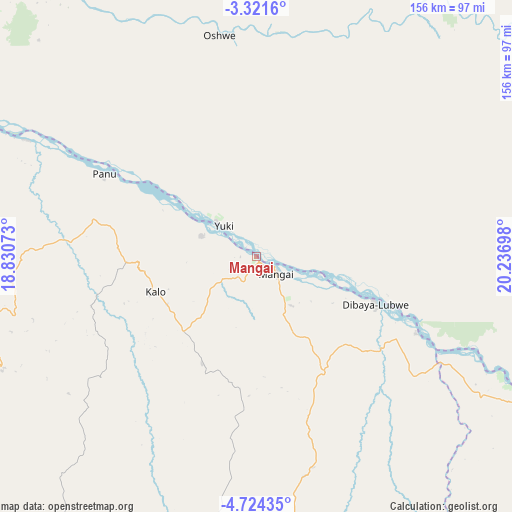
Mangai GPS coordinates[2]
4° 1' 23.808" South, 19° 32' 1.86" East
| Map corner | latitude | longitude |
|---|---|---|
| Upper-left | -3.3216°, | 18.83073° |
| Center: | -4.02328°, | 19.53385° |
| Lower-right: | -4.72435°, | 20.23698° |
| Map W x H: | 156×156 km | = 96.9×96.9mi |
| max Lat: | 4.279° ⇑51.4% North |
| Mangai: | -4.02328° |
| min Lat: | ⇓48.6% South -11.76097° |
| min Long | Mangai | max Long |
| 12.37148° | 19.53385° | 30.25224° |
| W 27.1%⇐ | ⇒72.9% E |
Elevation
Elevation of Mangai is 342 m = 1122 ft, and this is 314 m = 1030 ft below average elevation for this country.
| Max E: |
1996 m = 6549 ft | 81.4% |
| Avg. | 656 m = 2152 ft | |
| Mangai | 342 m = 1122 ft | |
Min E: |
11 m = 36 ft | 18.6% |
See also: Democratic Republic of the Congo elevation on elevation.city.
Geographical zone
Mangai is located in South Torrid zone (between Equator and Tropic of Capricorn). Distance of Equator is 447.3 km =277.9 mi to North.| Distance of | km | miles | from Mangai |
|---|---|---|---|
| Equator | 447.3 | 277.9 | to North |
| Tropic Capricorn | 2158.6 | 1341.3 | to South |
| Antarctic Circle | 6953.8 | 4320.9 | to South |
| South Pole | 9559.7 | 5940.1 | to South |


Nearby cities:
15 places around Mangai: (largest is in red/bold)
• Bandundu
251.5 km =156.3 mi,  288°
288°
• Bolobo
421.1 km =261.7 mi,  299°
299°
• Bulungu
118.3 km =73.5 mi,  240°
240°
• Demba
344.5 km =214.1 mi,  118°
118°
• Ilebo
121.6 km =75.6 mi,  106°
106°
• Inongo
271 km =168.4 mi,  329°
329°
• Kananga
381.2 km =236.9 mi, 123°
• Kasongo-Lunda
406.2 km =252.4 mi,  227°
227°
• Kikwit
138.3 km =85.9 mi,  215°
215°
• Luebo
256.1 km =159.1 mi,  125°
125°
• Lukolela
420.4 km =261.2 mi,  321°
321°
• Mushie
310.7 km =193.1 mi, 291°
• Mweka
242.7 km =150.8 mi, 112°
• Nioki
250.7 km =155.8 mi,  305°
305°
• Tshikapa
300.7 km =186.8 mi,  152°
152°
Sources, notices
• [Note1] Compared only with cities in Democratic Republic of the Congo existing in our database
• [Src1] Map data: © OpenStreetMap contributors (CC-BY-SA)
• [Src2] Other city data from geonames.org with taken over terms of usage.
• [Src3] Geographical zone / Annual Mean Temperature by Robert A. Rohde @ Wikipedia
