Mweka geodata
Mweka (Kasai) is a populated place; located in Democratic Republic of the Congo in Africa/Lubumbashi (GMT+2) time zone. With population of 50,675 people, there are 35 cities with bigger population in this country. Compared to other cities in Democratic Republic of the Congo, 61.4% of cities are located further ↑North; 57.1% of cities are located further →East and 60% of cities have lower elevation than Mweka. Note1


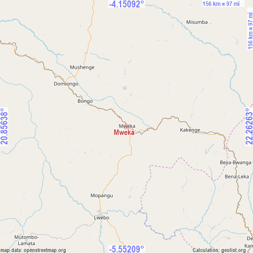
Mweka GPS coordinates[2]
4° 51' 6.732" South, 21° 33' 34.2" East
| Map corner | latitude | longitude |
|---|---|---|
| Upper-left | -4.15092°, | 20.85638° |
| Center: | -4.85187°, | 21.5595° |
| Lower-right: | -5.55209°, | 22.26263° |
| Map W x H: | 155.8×155.8 km | = 96.8×96.8mi |
| max Lat: | 4.279° ⇑61.4% North |
| Mweka: | -4.85187° |
| min Lat: | ⇓38.6% South -11.76097° |
| min Long | Mweka | max Long |
| 12.37148° | 21.5595° | 30.25224° |
| W 42.9%⇐ | ⇒57.1% E |
Elevation
Elevation of Mweka is 591 m = 1939 ft, and this is 65 m = 213 ft below average elevation for this country.
| Max E: |
1996 m = 6549 ft | 40% |
| Avg. | 656 m = 2152 ft | |
| Mweka | 591 m = 1939 ft | |
Min E: |
11 m = 36 ft | 60% |
See also: Mweka elevation on elevation.city.
Geographical zone
Mweka is located in South Torrid zone (between Equator and Tropic of Capricorn). Distance of Equator is 539.5 km =335.2 mi to North.| Distance of | km | miles | from Mweka |
|---|---|---|---|
| Equator | 539.5 | 335.2 | to North |
| Tropic Capricorn | 2066.4 | 1284 | to South |
| Antarctic Circle | 6861.7 | 4263.7 | to South |
| South Pole | 9467.6 | 5882.9 | to South |


Nearby cities:
14 places around Mweka: (largest is in red/bold)
• Bulungu
329.3 km =204.6 mi,  275°
275°
• Demba
106.3 km =66.1 mi,  132°
132°
• Gandajika
338.3 km =210.2 mi, 128°
• Ilebo
122.4 km =76.1 mi,  298°
298°
• Kabinda
353.6 km =219.7 mi,  113°
113°
• Kananga
150 km =93.2 mi,  140°
140°
• Kikwit
304.6 km =189.3 mi,  266°
266°
• Lodja
270.4 km =168 mi,  56°
56°
• Luebo
57.7 km =35.9 mi,  195°
195°
• Lusambo
209.2 km =130 mi,  93°
93°
• Mangai
242.7 km =150.8 mi,  292°
292°
• Mbuji-Mayi
266.2 km =165.4 mi,  122°
122°
• Mwene-Ditu
318.4 km =197.8 mi, 138°
• Tshikapa
193.2 km =120 mi,  205°
205°
Sources, notices
• [Note1] Compared only with cities in Democratic Republic of the Congo existing in our database
• [Src1] Map data: © OpenStreetMap contributors (CC-BY-SA)
• [Src2] Other city data from geonames.org with taken over terms of usage.
• [Src3] Geographical zone / Annual Mean Temperature by Robert A. Rohde @ Wikipedia
