Lusambo geodata
Lusambo (Sankuru) is a seat of a first-order administrative division; located in Democratic Republic of the Congo in Africa/Lubumbashi (GMT+2) time zone. With population of 41,416 people, there are 42 cities with bigger population in this country. Compared to other cities in Democratic Republic of the Congo, 62.9% of cities are located further ↑North; 51.4% of cities are located further →East and 60% of cities have higher elevation than Lusambo. Note1


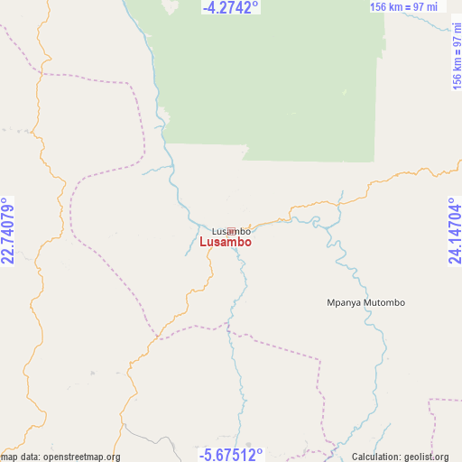
Lusambo GPS coordinates[2]
4° 58' 30.108" South, 23° 26' 38.076" East
| Map corner | latitude | longitude |
|---|---|---|
| Upper-left | -4.2742°, | 22.74079° |
| Center: | -4.97503°, | 23.44391° |
| Lower-right: | -5.67512°, | 24.14704° |
| Map W x H: | 155.8×155.8 km | = 96.8×96.8mi |
| max Lat: | 4.279° ⇑62.9% North |
| Lusambo: | -4.97503° |
| min Lat: | ⇓37.1% South -11.76097° |
| min Long | Lusambo | max Long |
| 12.37148° | 23.44391° | 30.25224° |
| W 48.6%⇐ | ⇒51.4% E |
Elevation
Elevation of Lusambo is 432 m = 1417 ft, and this is 224 m = 735 ft below average elevation for this country.
| Max E: |
1996 m = 6549 ft | 60% |
| Avg. | 656 m = 2152 ft | |
| Lusambo | 432 m = 1417 ft | |
Min E: |
11 m = 36 ft | 40% |
See also: Lusambo elevation on elevation.city.
Geographical zone
Lusambo is located in South Torrid zone (between Equator and Tropic of Capricorn). Distance of Equator is 553.2 km =343.7 mi to North.| Distance of | km | miles | from Lusambo |
|---|---|---|---|
| Equator | 553.2 | 343.7 | to North |
| Tropic Capricorn | 2052.7 | 1275.5 | to South |
| Antarctic Circle | 6848 | 4255.1 | to South |
| South Pole | 9453.9 | 5874.4 | to South |


Nearby cities:
15 places around Lusambo: (largest is in red/bold)
• Demba
142.3 km =88.4 mi,  245°
245°
• Gandajika
204.7 km =127.2 mi,  164°
164°
• Ilebo
324.7 km =201.8 mi,  282°
282°
• Kabinda
172.9 km =107.4 mi,  138°
138°
• Kampene
388.9 km =241.7 mi,  66°
66°
• Kananga
153 km =95.1 mi,  227°
227°
• Kasongo
362.3 km =225.1 mi,  80°
80°
• Kindu
355.8 km =221.1 mi,  50°
50°
• Lodja
162.6 km =101 mi,  6°
6°
• Lubao
259.3 km =161.1 mi,  100°
100°
• Luebo
227.8 km =141.5 mi,  259°
259°
• Mbuji-Mayi
130.1 km =80.8 mi,  172°
172°
• Mweka
209.2 km =130 mi,  273°
273°
• Mwene-Ditu
226.2 km =140.6 mi,  179°
179°
• Tshikapa
333.5 km =207.2 mi,  241°
241°
Sources, notices
• [Note1] Compared only with cities in Democratic Republic of the Congo existing in our database
• [Src1] Map data: © OpenStreetMap contributors (CC-BY-SA)
• [Src2] Other city data from geonames.org with taken over terms of usage.
• [Src3] Geographical zone / Annual Mean Temperature by Robert A. Rohde @ Wikipedia
