Luebo geodata
Luebo (Kasai) is a seat of a first-order administrative division; located in Democratic Republic of the Congo in Africa/Lubumbashi (GMT+2) time zone. With population of 35,183 people, there are 52 cities with bigger population in this country. Compared to other cities in Democratic Republic of the Congo, 68.6% of cities are located further ↑North; 60% of cities are located further →East and 52.9% of cities have lower elevation than Luebo. Note1


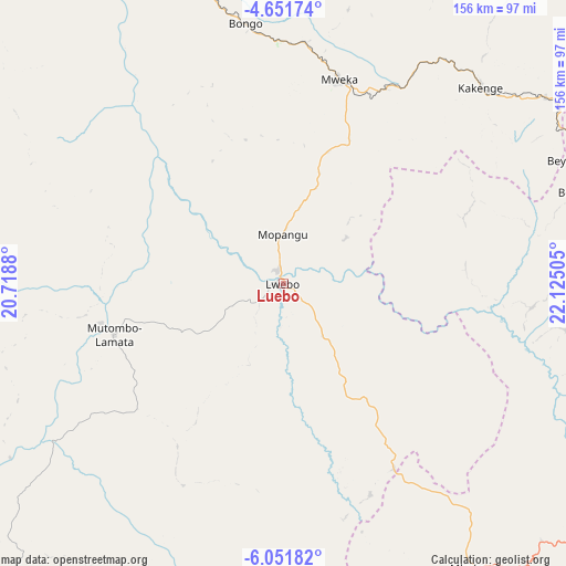
Luebo GPS coordinates[2]
5° 21' 7.848" South, 21° 25' 18.912" East
| Map corner | latitude | longitude |
|---|---|---|
| Upper-left | -4.65174°, | 20.7188° |
| Center: | -5.35218°, | 21.42192° |
| Lower-right: | -6.05182°, | 22.12505° |
| Map W x H: | 155.7×155.7 km | = 96.7×96.7mi |
| max Lat: | 4.279° ⇑68.6% North |
| Luebo: | -5.35218° |
| min Lat: | ⇓31.4% South -11.76097° |
| min Long | Luebo | max Long |
| 12.37148° | 21.42192° | 30.25224° |
| W 40%⇐ | ⇒60% E |
Elevation
Elevation of Luebo is 498 m = 1634 ft, and this is 158 m = 518 ft below average elevation for this country.
| Max E: |
1996 m = 6549 ft | 47.1% |
| Avg. | 656 m = 2152 ft | |
| Luebo | 498 m = 1634 ft | |
Min E: |
11 m = 36 ft | 52.9% |
See also: Democratic Republic of the Congo elevation on elevation.city.
Geographical zone
Luebo is located in South Torrid zone (between Equator and Tropic of Capricorn). Distance of Equator is 595.1 km =369.8 mi to North.| Distance of | km | miles | from Luebo |
|---|---|---|---|
| Equator | 595.1 | 369.8 | to North |
| Tropic Capricorn | 2010.8 | 1249.5 | to South |
| Antarctic Circle | 6806.1 | 4229.1 | to South |
| South Pole | 9412 | 5848.3 | to South |


Nearby cities:
14 places around Luebo: (largest is in red/bold)
• Bulungu
324.9 km =201.9 mi,  286°
286°
• Demba
95.2 km =59.2 mi,  99°
99°
• Gandajika
319.9 km =198.8 mi,  118°
118°
• Ilebo
146.5 km =91 mi,  320°
320°
• Kabinda
349.6 km =217.2 mi, 104°
• Kananga
125.6 km =78 mi, 118°
• Kikwit
290.6 km =180.6 mi,  276°
276°
• Lodja
315.9 km =196.3 mi,  49°
49°
• Lusambo
227.8 km =141.5 mi,  79°
79°
• Mangai
256.1 km =159.1 mi,  305°
305°
• Mbuji-Mayi
255.2 km =158.6 mi,  109°
109°
• Mweka
57.7 km =35.9 mi,  15°
15°
• Mwene-Ditu
290.4 km =180.4 mi,  129°
129°
• Tshikapa
136.9 km =85.1 mi,  210°
210°
Sources, notices
• [Note1] Compared only with cities in Democratic Republic of the Congo existing in our database
• [Src1] Map data: © OpenStreetMap contributors (CC-BY-SA)
• [Src2] Other city data from geonames.org with taken over terms of usage.
• [Src3] Geographical zone / Annual Mean Temperature by Robert A. Rohde @ Wikipedia
