Mongoumba geodata
Mongoumba (Lobaye) is a populated place; located in Central African Republic in Africa/Bangui (GMT+1) time zone. With population of 10,885 people, there are 27 cities with bigger population in this country. Compared to other cities in Central African Republic, 97.1% of cities are located further ↑North; 54.3% of cities are located further →East and 97.1% of cities have higher elevation than Mongoumba. Note1


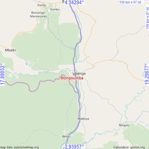
Mongoumba GPS coordinates[2]
3° 38' 29.508" North, 18° 35' 37.104" East
| Map corner | latitude | longitude |
|---|---|---|
| Upper-left | 4.34294°, | 17.89052° |
| Center: | 3.64153°, | 18.59364° |
| Lower-right: | 2.93957°, | 19.29677° |
| Map W x H: | 156×156 km | = 96.9×96.9mi |
| max Lat: | 10.28488° ⇑97.1% North |
| Mongoumba: | 3.64153° |
| min Lat: | ⇓2.9% South 3.52494° |
| min Long | Mongoumba | max Long |
| 15.13926° | 18.59364° | 26.49211° |
| W 45.7%⇐ | ⇒54.3% E |
Elevation
Elevation of Mongoumba is 356 m = 1168 ft, and this is 149.3 m = 490 ft below average elevation for this country.
| Max E: |
976 m = 3202 ft | 97.1% |
| Avg. | 505.3 m = 1658 ft | |
| Mongoumba | 356 m = 1168 ft | |
Min E: |
351 m = 1152 ft | 2.9% |
See also: Central African Republic elevation on elevation.city.
Geographical zone
Mongoumba is located in North Torrid zone (between Equator and Tropic of Cancer). Distance of Equator is 404.9 km =251.6 mi to South.| Distance of | km | miles | from Mongoumba |
|---|---|---|---|
| North Pole | 9602.2 | 5966.5 | to North |
| Arctic Circle | 6996.3 | 4347.3 | to North |
| Tropic Cancer | 2201 | 1367.6 | to North |
| Equator | 404.9 | 251.6 | to South |


Nearby cities:
15 places around Mongoumba: (largest is in red/bold)
• Alindao
328.3 km =204 mi,  62°
62°
• Bambari
330.3 km =205.2 mi,  44°
44°
• Bangui
80.1 km =49.8 mi,  356°
356°
• Berbérati
318.3 km =197.8 mi,  282°
282°
• Bimbo
71.2 km =44.2 mi,  343°
343°
• Boali
138.8 km =86.2 mi, 338°
• Boda
145.7 km =90.5 mi,  301°
301°
• Bouca
320.6 km =199.2 mi,  353°
353°
• Carnot
334.1 km =207.6 mi, 295°
• Damara
147.2 km =91.5 mi,  4°
4°
• Kouango
213.6 km =132.7 mi,  45°
45°
• Mbaïki
71.6 km =44.5 mi,  290°
290°
• Mobaye
296.5 km =184.2 mi,  75°
75°
• Nola
283 km =175.8 mi,  267°
267°
• Sibut
236.9 km =147.2 mi,  12°
12°
Sources, notices
• [Note1] Compared only with cities in Central African Republic existing in our database
• [Src1] Map data: © OpenStreetMap contributors (CC-BY-SA)
• [Src2] Other city data from geonames.org with taken over terms of usage.
• [Src3] Geographical zone / Annual Mean Temperature by Robert A. Rohde @ Wikipedia
