Carnot geodata
Carnot (Mambéré-Kadéï) is a populated place; located in Central African Republic in Africa/Bangui (GMT+1) time zone. With population of 38,071 people, there are 6 cities with bigger population in this country. Compared to other cities in Central African Republic, 60% of cities are located further ↑North; 91.4% of cities are located further →East and 68.6% of cities have lower elevation than Carnot. Note1


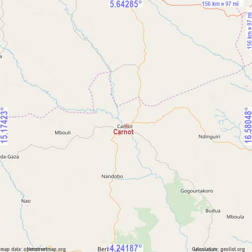
Carnot GPS coordinates[2]
4° 56' 33.828" North, 15° 52' 38.46" East
| Map corner | latitude | longitude |
|---|---|---|
| Upper-left | 5.64285°, | 15.17423° |
| Center: | 4.94273°, | 15.87735° |
| Lower-right: | 4.24187°, | 16.58048° |
| Map W x H: | 155.8×155.8 km | = 96.8×96.8mi |
| max Lat: | 10.28488° ⇑60% North |
| Carnot: | 4.94273° |
| min Lat: | ⇓40% South 3.52494° |
| min Long | Carnot | max Long |
| 15.13926° | 15.87735° | 26.49211° |
| W 8.6%⇐ | ⇒91.4% E |
Elevation
Elevation of Carnot is 551 m = 1808 ft, and this is 45.7 m = 150 ft above average elevation for this country.
| Max E: |
976 m = 3202 ft | 31.4% |
| Carnot | 551 m 1808 ft | |
| Avg. | 505.3 m = 1658 ft | |
Min E: |
351 m = 1152 ft | 68.6% |
See also: Central African Republic elevation on elevation.city.
Geographical zone
Carnot is located in North Torrid zone (between Equator and Tropic of Cancer). Distance of Equator is 549.6 km =341.5 mi to South.| Distance of | km | miles | from Carnot |
|---|---|---|---|
| North Pole | 9457.5 | 5876.6 | to North |
| Arctic Circle | 6851.6 | 4257.4 | to North |
| Tropic Cancer | 2056.3 | 1277.7 | to North |
| Equator | 549.6 | 341.5 | to South |


Nearby cities:
15 places around Carnot: (largest is in red/bold)
• Bangui
303.7 km =188.7 mi,  102°
102°
• Baoro
81.1 km =50.4 mi,  7°
7°
• Berbérati
76.4 km =47.5 mi,  187°
187°
• Bimbo
291.5 km =181.1 mi,  105°
105°
• Boali
249.8 km =155.2 mi,  93°
93°
• Boda
189.6 km =117.8 mi, 111°
• Bossangoa
245.3 km =152.4 mi,  45°
45°
• Bouar
114.5 km =71.1 mi,  344°
344°
• Bouca
317.4 km =197.2 mi,  56°
56°
• Bozoum
162.9 km =101.2 mi,  19°
19°
• Damara
313.1 km =194.6 mi, 89°
• Gamboula
122.9 km =76.4 mi,  221°
221°
• Mbaïki
262.9 km =163.4 mi,  117°
117°
• Nola
158.7 km =98.6 mi,  173°
173°
• Paoua
263.2 km =163.5 mi, 13°
Sources, notices
• [Note1] Compared only with cities in Central African Republic existing in our database
• [Src1] Map data: © OpenStreetMap contributors (CC-BY-SA)
• [Src2] Other city data from geonames.org with taken over terms of usage.
• [Src3] Geographical zone / Annual Mean Temperature by Robert A. Rohde @ Wikipedia
