Bangui geodata
Bangui is a capital of a political entity; located in Central African Republic in Africa/Bangui (GMT+1) time zone. With population of 542,393 people, there are 0 cities with bigger population in this country. Compared to other cities in Central African Republic, 74.3% of cities are located further ↑North; 57.1% of cities are located further →East and 100% of cities have higher elevation than Bangui. Note1


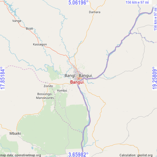
Bangui GPS coordinates[2]
4° 21' 40.392" North, 18° 33' 17.856" East
| Map corner | latitude | longitude |
|---|---|---|
| Upper-left | 5.06196°, | 17.85184° |
| Center: | 4.36122°, | 18.55496° |
| Lower-right: | 3.65982°, | 19.25809° |
| Map W x H: | 155.9×155.9 km | = 96.9×96.9mi |
| max Lat: | 10.28488° ⇑74.3% North |
| Bangui: | 4.36122° |
| min Lat: | ⇓25.7% South 3.52494° |
| min Long | Bangui | max Long |
| 15.13926° | 18.55496° | 26.49211° |
| W 42.9%⇐ | ⇒57.1% E |
Elevation
Elevation of Bangui is 351 m = 1152 ft, and this is 154.3 m = 506 ft below average elevation for this country.
| Max E: |
976 m = 3202 ft | 100% |
| Avg. | 505.3 m = 1658 ft | |
| Bangui | 351 m = 1152 ft | |
Min E: |
351 m = 1152 ft | 0% |
See also: Bangui elevation on elevation.city.
Geographical zone
Bangui is located in North Torrid zone (between Equator and Tropic of Cancer). Distance of Equator is 484.9 km =301.3 mi to South.| Distance of | km | miles | from Bangui |
|---|---|---|---|
| North Pole | 9522.1 | 5916.8 | to North |
| Arctic Circle | 6916.3 | 4297.6 | to North |
| Tropic Cancer | 2121 | 1317.9 | to North |
| Equator | 484.9 | 301.3 | to South |


Nearby cities:
15 places around Bangui: (largest is in red/bold)
• Alindao
303.2 km =188.4 mi,  75°
75°
• Bambari
282.2 km =175.4 mi,  56°
56°
• Bimbo
19.3 km =12 mi,  233°
233°
• Boali
68 km =42.3 mi,  315°
315°
• Boda
120.4 km =74.8 mi,  267°
267°
• Bossangoa
266.4 km =165.5 mi,  332°
332°
• Bouca
240.6 km =149.5 mi,  352°
352°
• Damara
68.7 km =42.7 mi,  13°
13°
• Kaga Bandoro
300.5 km =186.7 mi, 13°
• Kouango
171 km =106.3 mi,  65°
65°
• Mbaïki
83.3 km =51.8 mi, 228°
• Mobaye
290.9 km =180.8 mi,  90°
90°
• Mongoumba
80.1 km =49.8 mi,  176°
176°
• Nola
293.4 km =182.3 mi,  251°
251°
• Sibut
161.4 km =100.3 mi,  20°
20°
Sources, notices
• [Note1] Compared only with cities in Central African Republic existing in our database
• [Src1] Map data: © OpenStreetMap contributors (CC-BY-SA)
• [Src2] Other city data from geonames.org with taken over terms of usage.
• [Src3] Geographical zone / Annual Mean Temperature by Robert A. Rohde @ Wikipedia
