Bimbo geodata
Bimbo (Ombella-M'Poko) is a seat of a first-order administrative division; located in Central African Republic in Africa/Bangui (GMT+1) time zone. With population of 129,655 people, there is 1 city with bigger population in this country. Compared to other cities in Central African Republic, 88.6% of cities are located further ↑North; 60% of cities are located further →East and 91.4% of cities have higher elevation than Bimbo. Note1


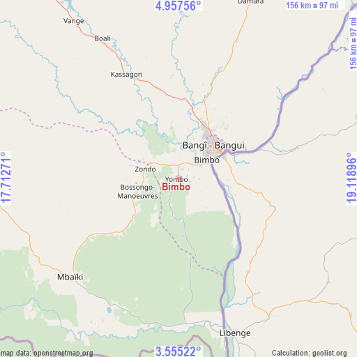
Bimbo GPS coordinates[2]
4° 15' 24.156" North, 18° 24' 56.988" East
| Map corner | latitude | longitude |
|---|---|---|
| Upper-left | 4.95756°, | 17.71271° |
| Center: | 4.25671°, | 18.41583° |
| Lower-right: | 3.55522°, | 19.11896° |
| Map W x H: | 155.9×155.9 km | = 96.9×96.9mi |
| max Lat: | 10.28488° ⇑88.6% North |
| Bimbo: | 4.25671° |
| min Lat: | ⇓11.4% South 3.52494° |
| min Long | Bimbo | max Long |
| 15.13926° | 18.41583° | 26.49211° |
| W 40%⇐ | ⇒60% E |
Elevation
Elevation of Bimbo is 371 m = 1217 ft, and this is 134.3 m = 441 ft below average elevation for this country.
| Max E: |
976 m = 3202 ft | 91.4% |
| Avg. | 505.3 m = 1658 ft | |
| Bimbo | 371 m = 1217 ft | |
Min E: |
351 m = 1152 ft | 8.6% |
See also: Bimbo elevation on elevation.city.
Geographical zone
Bimbo is located in North Torrid zone (between Equator and Tropic of Cancer). Distance of Equator is 473.3 km =294.1 mi to South.| Distance of | km | miles | from Bimbo |
|---|---|---|---|
| North Pole | 9533.8 | 5924 | to North |
| Arctic Circle | 6927.9 | 4304.8 | to North |
| Tropic Cancer | 2132.6 | 1325.1 | to North |
| Equator | 473.3 | 294.1 | to South |


Nearby cities:
15 places around Bimbo: (largest is in red/bold)
• Bambari
301.5 km =187.3 mi,  56°
56°
• Bangui
19.3 km =12 mi,  53°
53°
• Berbérati
290.9 km =180.8 mi,  270°
270°
• Boali
68.4 km =42.5 mi,  332°
332°
• Boda
105.2 km =65.4 mi, 273°
• Bossangoa
270.4 km =168 mi,  336°
336°
• Bouca
250.7 km =155.8 mi,  356°
356°
• Carnot
291.5 km =181.1 mi,  285°
285°
• Damara
84.5 km =52.5 mi,  22°
22°
• Kouango
189.9 km =118 mi, 64°
• Mbaïki
64.1 km =39.8 mi,  227°
227°
• Mobaye
306.4 km =190.4 mi,  88°
88°
• Mongoumba
71.2 km =44.2 mi,  163°
163°
• Nola
275.2 km =171 mi,  252°
252°
• Sibut
178.1 km =110.7 mi, 24°
Sources, notices
• [Note1] Compared only with cities in Central African Republic existing in our database
• [Src1] Map data: © OpenStreetMap contributors (CC-BY-SA)
• [Src2] Other city data from geonames.org with taken over terms of usage.
• [Src3] Geographical zone / Annual Mean Temperature by Robert A. Rohde @ Wikipedia
