Berbérati geodata
Berbérati (Mambéré-Kadéï) is a seat of a first-order administrative division; located in Central African Republic in Africa/Bangui (GMT+1) time zone. With population of 61,815 people, there are 3 cities with bigger population in this country. Compared to other cities in Central African Republic, 85.7% of cities are located further ↑North; 94.3% of cities are located further →East and 82.9% of cities have lower elevation than Berbérati. Note1


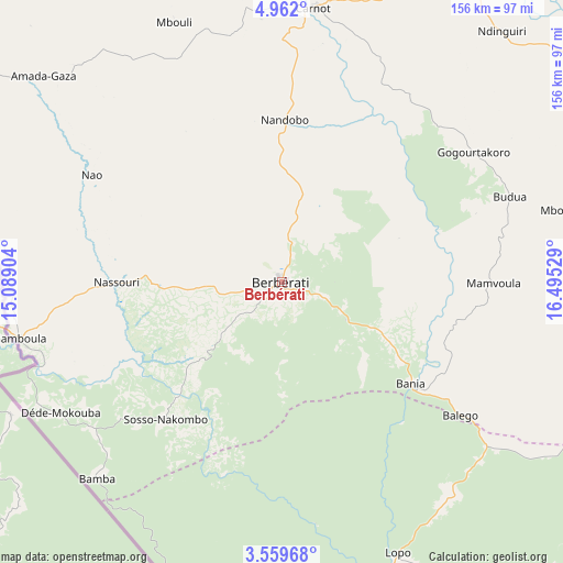
Berbérati GPS coordinates[2]
4° 15' 40.176" North, 15° 47' 31.776" East
| Map corner | latitude | longitude |
|---|---|---|
| Upper-left | 4.962°, | 15.08904° |
| Center: | 4.26116°, | 15.79216° |
| Lower-right: | 3.55968°, | 16.49529° |
| Map W x H: | 155.9×155.9 km | = 96.9×96.9mi |
| max Lat: | 10.28488° ⇑85.7% North |
| Berbérati: | 4.26116° |
| min Lat: | ⇓14.3% South 3.52494° |
| min Long | Berbérati | max Long |
| 15.13926° | 15.79216° | 26.49211° |
| W 5.7%⇐ | ⇒94.3% E |
Elevation
Elevation of Berbérati is 599 m = 1965 ft, and this is 93.7 m = 307 ft above average elevation for this country.
| Max E: |
976 m = 3202 ft | 17.1% |
| Berbérati | 599 m 1965 ft | |
| Avg. | 505.3 m = 1658 ft | |
Min E: |
351 m = 1152 ft | 82.9% |
See also: Berbérati elevation on elevation.city.
Geographical zone
Berbérati is located in North Torrid zone (between Equator and Tropic of Cancer). Distance of Equator is 473.8 km =294.4 mi to South.| Distance of | km | miles | from Berbérati |
|---|---|---|---|
| North Pole | 9533.3 | 5923.7 | to North |
| Arctic Circle | 6927.4 | 4304.5 | to North |
| Tropic Cancer | 2132.1 | 1324.8 | to North |
| Equator | 473.8 | 294.4 | to South |


Nearby cities:
15 places around Berbérati: (largest is in red/bold)
• Bangui
306.5 km =190.5 mi,  87°
87°
• Baoro
157.5 km =97.9 mi,  7°
7°
• Bimbo
290.9 km =180.8 mi, 90°
• Boali
265.7 km =165.1 mi,  76°
76°
• Boda
186.1 km =115.6 mi, 88°
• Bossangoa
308.9 km =191.9 mi,  36°
36°
• Bouar
187.3 km =116.4 mi,  353°
353°
• Bozoum
237.9 km =147.8 mi,  15°
15°
• Carnot
76.4 km =47.5 mi, 7°
• Damara
331.9 km =206.2 mi, 76°
• Gamboula
74.1 km =46 mi,  257°
257°
• Mbaïki
247.6 km =153.9 mi,  100°
100°
• Mongoumba
318.3 km =197.8 mi, 102°
• Nola
86.6 km =53.8 mi,  161°
161°
• Paoua
339.2 km =210.8 mi, 12°
Sources, notices
• [Note1] Compared only with cities in Central African Republic existing in our database
• [Src1] Map data: © OpenStreetMap contributors (CC-BY-SA)
• [Src2] Other city data from geonames.org with taken over terms of usage.
• [Src3] Geographical zone / Annual Mean Temperature by Robert A. Rohde @ Wikipedia
