Mbaïki geodata
Mbaïki (Lobaye) is a seat of a first-order administrative division; located in Central African Republic in Africa/Bangui (GMT+1) time zone. With population of 67,132 people, there are 2 cities with bigger population in this country. Compared to other cities in Central African Republic, 94.3% of cities are located further ↑North; 71.4% of cities are located further →East and 51.4% of cities have lower elevation than Mbaïki. Note1


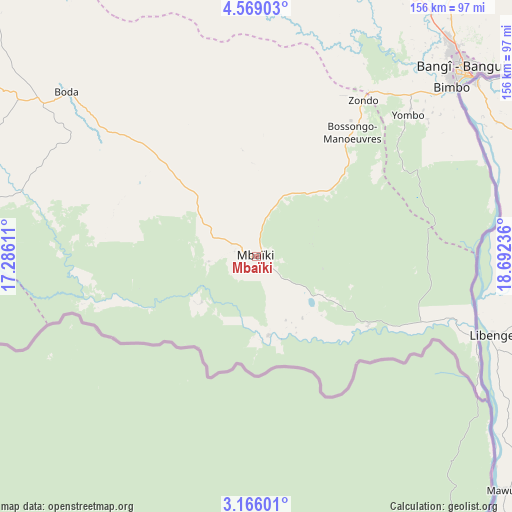
Mbaïki GPS coordinates[2]
3° 52' 4.116" North, 17° 59' 21.228" East
| Map corner | latitude | longitude |
|---|---|---|
| Upper-left | 4.56903°, | 17.28611° |
| Center: | 3.86781°, | 17.98923° |
| Lower-right: | 3.16601°, | 18.69236° |
| Map W x H: | 156×156 km | = 96.9×96.9mi |
| max Lat: | 10.28488° ⇑94.3% North |
| Mbaïki: | 3.86781° |
| min Lat: | ⇓5.7% South 3.52494° |
| min Long | Mbaïki | max Long |
| 15.13926° | 17.98923° | 26.49211° |
| W 28.6%⇐ | ⇒71.4% E |
Elevation
Elevation of Mbaïki is 476 m = 1562 ft, and this is 29.3 m = 96 ft below average elevation for this country.
| Max E: |
976 m = 3202 ft | 48.6% |
| Avg. | 505.3 m = 1658 ft | |
| Mbaïki | 476 m = 1562 ft | |
Min E: |
351 m = 1152 ft | 51.4% |
See also: Mbaïki elevation on elevation.city.
Geographical zone
Mbaïki is located in North Torrid zone (between Equator and Tropic of Cancer). Distance of Equator is 430.1 km =267.3 mi to South.| Distance of | km | miles | from Mbaïki |
|---|---|---|---|
| North Pole | 9577 | 5950.9 | to North |
| Arctic Circle | 6971.1 | 4331.6 | to North |
| Tropic Cancer | 2175.9 | 1352 | to North |
| Equator | 430.1 | 267.3 | to South |


Nearby cities:
15 places around Mbaïki: (largest is in red/bold)
• Bangui
83.3 km =51.8 mi,  48°
48°
• Baoro
300.4 km =186.7 mi,  311°
311°
• Berbérati
247.6 km =153.9 mi,  280°
280°
• Bimbo
64.1 km =39.8 mi, 47°
• Boali
104.8 km =65.1 mi,  8°
8°
• Boda
76.4 km =47.5 mi, 311°
• Bossangoa
297.8 km =185 mi,  348°
348°
• Bouca
295.2 km =183.4 mi, 6°
• Carnot
262.9 km =163.4 mi,  297°
297°
• Damara
145 km =90.1 mi,  33°
33°
• Gamboula
317.3 km =197.2 mi, 275°
• Kouango
252 km =156.6 mi,  60°
60°
• Mongoumba
71.6 km =44.5 mi,  110°
110°
• Nola
219 km =136.1 mi,  259°
259°
• Sibut
238.3 km =148.1 mi, 30°
Sources, notices
• [Note1] Compared only with cities in Central African Republic existing in our database
• [Src1] Map data: © OpenStreetMap contributors (CC-BY-SA)
• [Src2] Other city data from geonames.org with taken over terms of usage.
• [Src3] Geographical zone / Annual Mean Temperature by Robert A. Rohde @ Wikipedia
