Kaga Bandoro geodata
Kaga Bandoro (Nana-Grébizi) is a seat of a first-order administrative division; located in Central African Republic in Africa/Bangui (GMT+1) time zone. With population of 56,520 people, there are 4 cities with bigger population in this country. Compared to other cities in Central African Republic, 82.9% of cities are located further ↓South; 57.1% of cities are located further ←West and 74.3% of cities have higher elevation than Kaga Bandoro. Note1


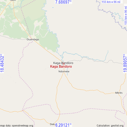
Kaga Bandoro GPS coordinates[2]
6° 59' 22.596" North, 19° 11' 14.784" East
| Map corner | latitude | longitude |
|---|---|---|
| Upper-left | 7.68697°, | 18.48432° |
| Center: | 6.98961°, | 19.18744° |
| Lower-right: | 6.29121°, | 19.89057° |
| Map W x H: | 155.2×155.2 km | = 96.4×96.4mi |
| max Lat: | 10.28488° ⇑17.1% North |
| Kaga Bandoro: | 6.98961° |
| min Lat: | ⇓82.9% South 3.52494° |
| min Long | Kaga Bandoro | max Long |
| 15.13926° | 19.18744° | 26.49211° |
| W 57.1%⇐ | ⇒42.9% E |
Elevation
Elevation of Kaga Bandoro is 416 m = 1365 ft, and this is 89.3 m = 293 ft below average elevation for this country.
| Max E: |
976 m = 3202 ft | 74.3% |
| Avg. | 505.3 m = 1658 ft | |
| Kaga Bandoro | 416 m = 1365 ft | |
Min E: |
351 m = 1152 ft | 25.7% |
See also: Kaga Bandoro elevation on elevation.city.
Geographical zone
Kaga Bandoro is located in North Torrid zone (between Equator and Tropic of Cancer). Distance of Equator is 777.2 km =482.9 mi to South.| Distance of | km | miles | from Kaga Bandoro |
|---|---|---|---|
| North Pole | 9229.9 | 5735.2 | to North |
| Arctic Circle | 6624 | 4116 | to North |
| Tropic Cancer | 1828.7 | 1136.3 | to North |
| Equator | 777.2 | 482.9 | to South |


Nearby cities:
15 places around Kaga Bandoro: (largest is in red/bold)
• Alindao
312.4 km =194.1 mi,  134°
134°
• Bambari
213.3 km =132.5 mi, 129°
• Bangui
300.5 km =186.7 mi,  193°
193°
• Batangafo
105.6 km =65.6 mi,  289°
289°
• Boali
270.2 km =167.9 mi,  205°
205°
• Bossangoa
199.1 km =123.7 mi,  253°
253°
• Bouca
114 km =70.8 mi,  241°
241°
• Bria
313 km =194.5 mi,  99°
99°
• Damara
231.8 km =144 mi, 193°
• Ippy
238.9 km =148.4 mi,  109°
109°
• Kabo
100.1 km =62.2 mi,  322°
322°
• Kouango
237.9 km =147.8 mi,  158°
158°
• Ndélé
225.5 km =140.1 mi,  45°
45°
• Paoua
304.4 km =189.1 mi,  275°
275°
• Sibut
141.9 km =88.2 mi, 185°
Sources, notices
• [Note1] Compared only with cities in Central African Republic existing in our database
• [Src1] Map data: © OpenStreetMap contributors (CC-BY-SA)
• [Src2] Other city data from geonames.org with taken over terms of usage.
• [Src3] Geographical zone / Annual Mean Temperature by Robert A. Rohde @ Wikipedia
